
Città di Castello topographic map
Interactive map
Click on the map to display elevation.
About this map
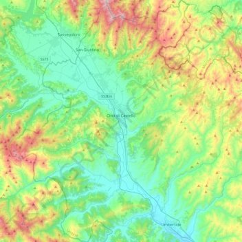
Name: Città di Castello topographic map, elevation, terrain.
Location: Città di Castello, Perugia, Umbrië, Italië (43.28135 12.07278 43.61734 12.43482)
Average elevation: 504 m
Minimum elevation: 230 m
Maximum elevation: 1,213 m
Other topographic maps
Click on a map to view its topography, its elevation and its terrain.
Morra
Italië > Umbrië > Perugia > Città di Castello
Morra, Città di Castello, Perugia, Umbrië, Italië
Average elevation: 426 m