
Thank you for supporting this site ❤️
Make a donation
Make a donation
Harmukh topographic map
Click on the map to display elevation.
Thank you for supporting this site ❤️
Make a donation
Make a donation
About this map
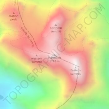
Name: Harmukh topographic map, elevation, terrain.
Location: Harmukh, Kangan, Ganderbal district, Jammu and Kashmir, India (34.40387 74.90196 34.40397 74.90206)
Average elevation: 4,488 m
Minimum elevation: 3,678 m
Maximum elevation: 5,124 m
Thank you for supporting this site ❤️
Make a donation
Make a donation