
Thank you for supporting this site ❤️
Make a donation
Make a donation
Kandal topographic map
Click on the map to display elevation.
Thank you for supporting this site ❤️
Make a donation
Make a donation
Kandal
The province consists of the typical plain wet area, covering rice fields and other agricultural plantations. The average altitude of the province is no more than 10 meters above sea level. The province also features two of the biggest rivers in the country, the Bassac and Mekong Rivers.
Thank you for supporting this site ❤️
Make a donation
Make a donation
About this map
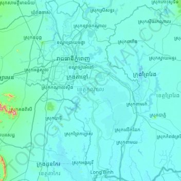
Name: Kandal topographic map, elevation, terrain.
Location: Kandal, Cambodia (10.89648 104.65622 11.89431 105.29716)
Average elevation: 16 m
Minimum elevation: -1 m
Maximum elevation: 678 m
Thank you for supporting this site ❤️
Make a donation
Make a donation
Other topographic maps
Click on a map to view its topography, its elevation and its terrain.