
New Lexington topographic map
Interactive map
Click on the map to display elevation.
About this map
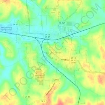
Name: New Lexington topographic map, elevation, terrain.
Location: New Lexington, Perry County, Ohio, United States (39.69611 -82.22455 39.73168 -82.18130)
Average elevation: 279 m
Minimum elevation: 255 m
Maximum elevation: 311 m
Other topographic maps
Click on a map to view its topography, its elevation and its terrain.
Glenford
United States > Ohio > Perry County
Glenford, Perry County, Ohio, United States
Average elevation: 273 m
Portersville
United States > Ohio > Perry County
Portersville, Perry County, Ohio, United States
Average elevation: 302 m
Corning
United States > Ohio > Perry County
Corning, Perry County, Ohio, United States
Average elevation: 254 m
Shawnee
United States > Ohio > Perry County
Shawnee, Perry County, Ohio, 43782, United States
Average elevation: 278 m
New Straitsville
United States > Ohio > Perry County
New Straitsville, Perry County, Ohio, United States
Average elevation: 278 m
Mount Perry
United States > Ohio > Perry County
Mount Perry, Perry County, Ohio, 43760, United States
Average elevation: 273 m
Crooksville
United States > Ohio > Perry County
Crooksville, Perry County, Ohio, United States
Average elevation: 261 m
Glass Rock
United States > Ohio > Perry County
Glass Rock, Perry County, Ohio, 43739, United States
Average elevation: 283 m