Glenford topographic map
Interactive map
Click on the map to display elevation.
About this map
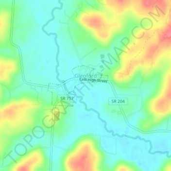
Name: Glenford topographic map, elevation, terrain.
Location: Glenford, Perry County, Ohio, United States (39.88329 -82.32481 39.88976 -82.31251)
Average elevation: 273 m
Minimum elevation: 248 m
Maximum elevation: 320 m
Other topographic maps
Click on a map to view its topography, its elevation and its terrain.
Portersville
United States > Ohio > Perry County
Portersville, Perry County, Ohio, United States
Average elevation: 302 m
Corning
United States > Ohio > Perry County
Corning, Perry County, Ohio, United States
Average elevation: 254 m
Shawnee
United States > Ohio > Perry County
Shawnee, Perry County, Ohio, 43782, United States
Average elevation: 278 m
New Straitsville
United States > Ohio > Perry County
New Straitsville, Perry County, Ohio, United States
Average elevation: 278 m
Mount Perry
United States > Ohio > Perry County
Mount Perry, Perry County, Ohio, 43760, United States
Average elevation: 273 m
Crooksville
United States > Ohio > Perry County
Crooksville, Perry County, Ohio, United States
Average elevation: 261 m
Glass Rock
United States > Ohio > Perry County
Glass Rock, Perry County, Ohio, 43739, United States
Average elevation: 283 m
New Lexington
United States > Ohio > Perry County
New Lexington, Perry County, Ohio, United States
Average elevation: 279 m