
Seni District topographic map
Interactive map
Click on the map to display elevation.
About this map
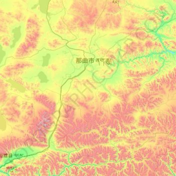
Name: Seni District topographic map, elevation, terrain.
Location: Seni District, Nagqu City, Tibet, PRC (30.51473 90.99093 31.87279 93.01559)
Average elevation: 4,869 m
Minimum elevation: 4,132 m
Maximum elevation: 6,417 m
Other topographic maps
Click on a map to view its topography, its elevation and its terrain.
Brahmaputra
Brahmaputra, Nagarzê County, Shannan, Tibet, PRC
Average elevation: 2,298 m
Shishapangma
Shishapangma, 聂拉木县, Nyalam County, Shigatse, Tibet, PRC
Average elevation: 7,232 m
Norbulingka
Norbulingka, 加措社区, Gündêling, Chengguan District, Lhasa, Tibet, PRC
Average elevation: 3,648 m
Yarlung Zangbo
Yarlung Zangbo, Qüxü, Qüxü County, Lhasa, Tibet, PRC
Average elevation: 3,647 m