
Thank you for supporting this site ❤️
Make a donation
Make a donation
Iranamadu topographic map
Click on the map to display elevation.
Thank you for supporting this site ❤️
Make a donation
Make a donation
About this map
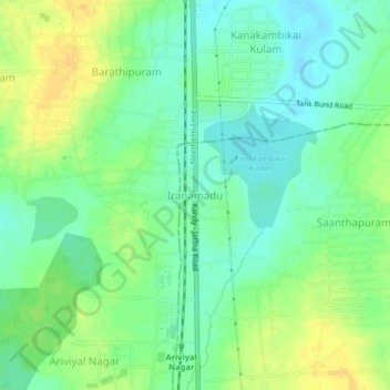
Name: Iranamadu topographic map, elevation, terrain.
Location: Iranamadu, Mullaitivu District, Northern Province, Sri Lanka (9.31427 80.38922 9.35427 80.42922)
Average elevation: 39 m
Minimum elevation: 27 m
Maximum elevation: 53 m
Thank you for supporting this site ❤️
Make a donation
Make a donation
Other topographic maps
Click on a map to view its topography, its elevation and its terrain.
Kayts
Sri Lanka > Northern Province > Saravanai
Velani is located at 9°24′N 79°32′E / 9.40°N 79.54°E / 9.40; 79.54. It is surrounded by the Palk Strait and at a distance of 6 kilometres (3.7 mi) south-west of Jaffna town. Though most of Velani district is a level plain and also has maximum elevation of 15 metres (49 ft) above mean sea…
Average elevation: 2 m
Thank you for supporting this site ❤️
Make a donation
Make a donation