
Thank you for supporting this site ❤️
Make a donation
Make a donation
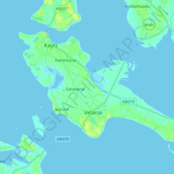
Kayts topographic map
Click on the map to display elevation.
Thank you for supporting this site ❤️
Make a donation
Make a donation
Kayts
Velani is located at 9°24′N 79°32′E / 9.40°N 79.54°E / 9.40; 79.54. It is surrounded by the Palk Strait and at a distance of 6 kilometres (3.7 mi) south-west of Jaffna town. Though most of Velani district is a level plain and also has maximum elevation of 15 metres (49 ft) above mean sea level. The total area of this island is nearly 36 km2.
Thank you for supporting this site ❤️
Make a donation
Make a donation
About this map
Name: Kayts topographic map, elevation, terrain.
Location: Kayts, Saravanai, Jaffna District, Northern Province, Sri Lanka (9.61235 79.84043 9.70347 79.98518)
Average elevation: 2 m
Minimum elevation: -2 m
Maximum elevation: 13 m
Thank you for supporting this site ❤️
Make a donation
Make a donation