
King County topographic map
Interactive map
Click on the map to display elevation.
About this map
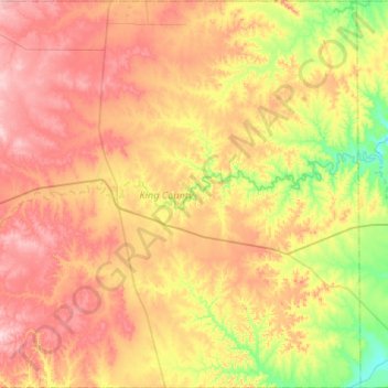
Name: King County topographic map, elevation, terrain.
Location: King County, Texas, 79236, United States of America (33.39699 -100.51864 33.83599 -99.99095)
Average elevation: 540 m
Minimum elevation: 434 m
Maximum elevation: 654 m
Other topographic maps
Click on a map to view its topography, its elevation and its terrain.
Houston
United States of America > Texas > Houston
Houston is located 165 miles (266 km) east of Austin, 88 miles (142 km) west of the Louisiana border, and 250 miles (400 km) south of Dallas. The city has a total area of 637.4 square miles (1,651 km2); this comprises over 599.59 square miles (1,552.9 km2) of land and 22.3 square miles (58 km2) covered by…
Average elevation: 18 m