
Make a donation
Knox County topographic map
Click on the map to display elevation.
Make a donation
Knox County
According to the U.S. Census Bureau, the county has a total area of 530 square miles (1,400 km2), of which 525 square miles (1,360 km2) is land and 4.1 square miles (11 km2) (0.8%) is water. Approximately 58% of the county is farmland and 28% is forested. Most of the county lies in the Glaciated Allegheny Plateau with rolling hills and valleys. Although the relief is not sharp, some elevations in the county reach over 1400 feet above sea level.
Make a donation
About this map
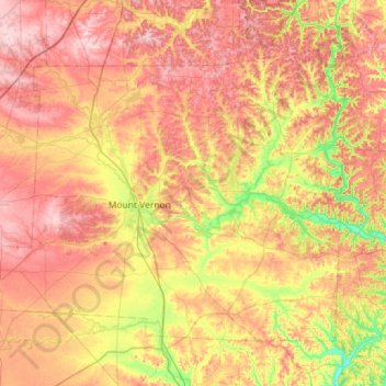
Name: Knox County topographic map, elevation, terrain.
Location: Knox County, Ohio, United States (40.23909 -82.75075 40.57307 -82.17855)
Average elevation: 345 m
Minimum elevation: 239 m
Maximum elevation: 441 m
Make a donation
Other topographic maps
Click on a map to view its topography, its elevation and its terrain.
Cleveland
United States > Ohio > Cuyahoga County > Cleveland
The land rises quickly from the lake shore elevation of 569 feet. Public Square, less than one mile (1.6 km) inland, sits at an elevation of 650 feet (198 m), and Hopkins Airport, 5 miles (8 km) inland from the lake, is at an elevation of 791 feet (241 m).
Average elevation: 221 m
Make a donation
Columbus
United States > Ohio > Franklin County > Columbus
The confluence of the Scioto and Olentangy rivers is just north-west of Downtown Columbus. Several smaller tributaries course through the Columbus metropolitan area, including Alum Creek, Big Walnut Creek, and Darby Creek. Columbus is considered to have relatively flat topography thanks to a large glacier that…
Average elevation: 255 m
Montgomery Heights
United States > Ohio > Hamilton County > Montgomery > Montgomery Heights
Average elevation: 241 m
Mansfield
United States > Ohio > Richland County > Mansfield > Mansfield
Mansfield is located at 40°45′17″N 82°31′22″W / 40.75472°N 82.52278°W / 40.75472; -82.52278 (40.754856, −82.522855), directly between Columbus and Cleveland, however, the city lies in the western foothills of the Allegheny Plateau, and its elevation is among the highest of Ohio cities.…
Average elevation: 371 m
Make a donation