
Thank you for supporting this site ❤️
Make a donation
Make a donation
Kokernag topographic map
Click on the map to display elevation.
Thank you for supporting this site ❤️
Make a donation
Make a donation
About this map
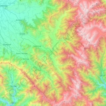
Name: Kokernag topographic map, elevation, terrain.
Location: Kokernag, Anantnag District, Jammu and Kashmir, 192202, India (33.36373 75.18914 33.75760 75.52770)
Average elevation: 2,646 m
Minimum elevation: 1,462 m
Maximum elevation: 4,440 m
Thank you for supporting this site ❤️
Make a donation
Make a donation