
Thank you for supporting this site ❤️
Make a donation
Make a donation
Jakhama topographic map
Click on the map to display elevation.
Thank you for supporting this site ❤️
Make a donation
Make a donation
About this map
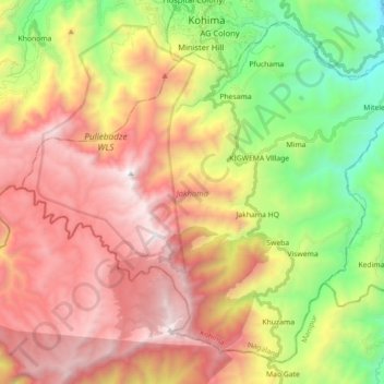
Name: Jakhama topographic map, elevation, terrain.
Location: Jakhama, Kohima, Nagaland, 797005, India (25.51847 94.01613 25.66104 94.19455)
Average elevation: 1,907 m
Minimum elevation: 816 m
Maximum elevation: 3,001 m
Thank you for supporting this site ❤️
Make a donation
Make a donation
Other topographic maps
Click on a map to view its topography, its elevation and its terrain.