
Thank you for supporting this site ❤️
Make a donation
Make a donation
Mondulkiri topographic map
Click on the map to display elevation.
Thank you for supporting this site ❤️
Make a donation
Make a donation
Mondulkiri
Mondulkiri is Cambodia's largest and also most sparsely populated province, containing an area of 14,288 km2 (5,517 sq mi) with elevations ranging from 190 to 1,000 metres (620 to 3,280 ft). It is located in the south-east part of the country and borders three provinces in Vietnam; Đắk Lắk, Đắk Nông, and Bình Phước provinces. Three rivers cross the province; Srepok, Preaek Chhbaar, and Preaek te Rivers.
Thank you for supporting this site ❤️
Make a donation
Make a donation
About this map
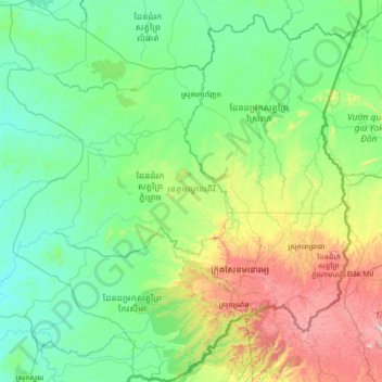
Name: Mondulkiri topographic map, elevation, terrain.
Location: Mondulkiri, Cambodia (12.06196 106.33858 13.41751 107.60331)
Average elevation: 254 m
Minimum elevation: 41 m
Maximum elevation: 1,208 m
Thank you for supporting this site ❤️
Make a donation
Make a donation
Other topographic maps
Click on a map to view its topography, its elevation and its terrain.
Thank you for supporting this site ❤️
Make a donation
Make a donation
Thank you for supporting this site ❤️
Make a donation
Make a donation