Geolocate

Bantey Meanchey topographic map

Interactive map

Click on the map to display elevation.

About this map

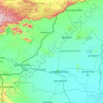
Name: Bantey Meanchey topographic map, elevation, terrain.

Location: Bantey Meanchey, Cambodia (13.35794 102.33383 14.25023 103.44273)

Average elevation: 94 m

Minimum elevation: 5 m

Maximum elevation: 751 m

Other topographic maps

Click on a map to view its topography, its elevation and its terrain.

Koh Dach

Cambodia > Phnom Penh > Khan Chroy Changvar

Average elevation: 9 m

Kampot

Cambodia > Kampot

Average elevation: 120 m

Kampong Siem

Cambodia > Kampong Cham

Average elevation: 33 m

Thma Bang

Cambodia > Koh Kong

Average elevation: 464 m

Khum Longvek

Cambodia > Kampong Chhnang > Khum Longvek

Average elevation: 13 m

Koh Kong

Cambodia > Koh Kong

Average elevation: 53 m

Senmonorom

Cambodia > Mondulkiri > Senmonorom

Average elevation: 587 m

Siem Reap

Cambodia > Siem Reap > Siem Reap Municipality

Average elevation: 15 m