
Tukuma novads topographic map
Interactive map
Click on the map to display elevation.
About this map
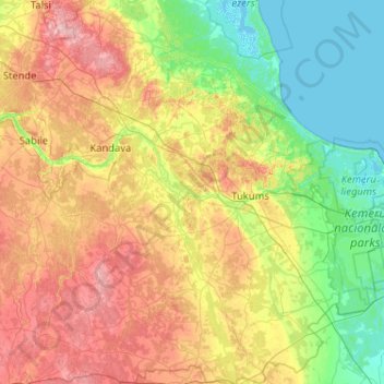
Name: Tukuma novads topographic map, elevation, terrain.
Location: Tukuma novads, Koerland, Letland (56.69129 22.80607 57.25229 23.50617)
Average elevation: 58 m
Minimum elevation: -2 m
Maximum elevation: 170 m
Other topographic maps
Click on a map to view its topography, its elevation and its terrain.
Bigauņciems
Letland > Koerland > Tukuma novads > Lapmežciema pagasts
Bigauņciems, Lapmežciema pagasts, Tukuma novads, Koerland, Letland
Average elevation: 2 m