
Make a donation
Rhondda Cynon Taf topographic map
Click on the map to display elevation.
Make a donation
About this map
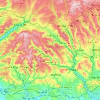
Name: Rhondda Cynon Taf topographic map, elevation, terrain.
Location: Rhondda Cynon Taf, Wales, United Kingdom (51.49904 -3.59371 51.83012 -3.23631)
Average elevation: 251 m
Minimum elevation: 12 m
Maximum elevation: 616 m
Make a donation
Other topographic maps
Click on a map to view its topography, its elevation and its terrain.
Make a donation
Ruthin
United Kingdom > Wales > Denbighshire
The Myddleton Arms is also known as the Seven Eyes. It is said to have been built in the 14th century. The Dutch style design, long, steeped roof is attributed to Sir Richard Clough, an Elizabethan merchant. It has four tiers of dormer windows, each at a different elevation, known locally as the seven eyes of…
Average elevation: 162 m
Green Bridge of Wales
United Kingdom > Wales > Pembrokeshire > Warren > Flimston
Average elevation: 21 m
Make a donation
Usk
United Kingdom > Wales > Monmouthshire
The origin of the Welsh name Brynbuga (Welsh: [brɨ̞nˈbɨ̞ga]) is less certain. The local Brythonic name adopted into Latin as Burrium or Burrio was recorded as Brunebegy and Burenbegie in the 15th century. The modern name is likely an example of the linguistic metathesis common in Welsh Topography. Folk…
Average elevation: 66 m
Make a donation
Make a donation
Snowdon
United Kingdom > Wales > Gwynedd > Betws Garmon
Snowdon (/ˈsnoʊdən/) or Yr Wyddfa (pronounced [ər ˈʊɨ̞̯ðva] (listen)), is the highest mountain in Wales, at an elevation of 1,085 metres (3,560 ft) above sea level, and the highest point in the British Isles outside the Scottish Highlands. It is located in Snowdonia National Park (Parc Cenedlaethol…
Average elevation: 692 m
Make a donation
Swansea
United Kingdom > Wales > Swansea
Much of Swansea is hilly with the main area of upland being located in the council ward of Mawr. Areas up to 185 metres (607 ft) in elevation range across the central section: Kilvey Hill, Townhill and Llwynmawr separate the centre of Swansea from its northern suburbs. Cefn Bryn, a ridge of high land, is the…
Average elevation: 73 m
Make a donation
Treborth-uchaf-Farm
United Kingdom > Wales > Gwynedd > Menai Bridge > Treborth-uchaf-Farm
Average elevation: 48 m