
Distrito Sur topographic map
Interactive map
Click on the map to display elevation.
About this map
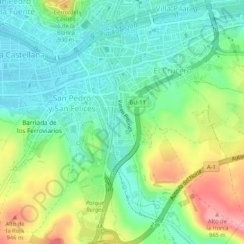
Name: Distrito Sur topographic map, elevation, terrain.
Location: Distrito Sur, Burgos, Castilla y León, España (42.31646 -3.71447 42.34339 -3.67908)
Average elevation: 889 m
Minimum elevation: 850 m
Maximum elevation: 963 m
Other topographic maps
Click on a map to view its topography, its elevation and its terrain.