
Xuanhua District topographic map
Interactive map
Click on the map to display elevation.
About this map
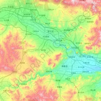
Name: Xuanhua District topographic map, elevation, terrain.
Location: Xuanhua District, Zhangjiakou, Hebei, 075200, China (40.15388 114.69463 40.80853 115.52043)
Average elevation: 945 m
Minimum elevation: 478 m
Maximum elevation: 1,978 m
In the late 14th century, prior to his elevation to emperor of the Ming Empire, Zhu Di ruled his principality of Yan from Xuanhua. Under the Qing, it continued to serve as the seat of a prefecture and was known to the Jesuit missionaries as "Suen-hao-fou".
Other topographic maps
Click on a map to view its topography, its elevation and its terrain.
Sanquzhuangcun
China > Hebei > Baoding City
Sanquzhuangcun, Baoding City, Hebei, China
Average elevation: 133 m
Huai'an County
China > Hebei > Zhangjiakou
Huai'an County, Zhangjiakou, Hebei, China
Average elevation: 1,103 m
Guangyang District
Guangyang District, Langfang, Hebei, 102802, China
Average elevation: 16 m
Xinhua District
Xinhua District, Shijiazhuang, Hebei, 050051, China
Average elevation: 81 m
Chezhan Subdistrict
Chezhan Subdistrict, Xinhua District, Cangzhou, Hebei, 061000, China
Average elevation: 10 m
Luannan County
China > Hebei > Tangshan City
Luannan County, Tangshan City, Hebei, China
Average elevation: 5 m
Laoting County
China > Hebei > Tangshan City
Laoting County, Tangshan City, Hebei, China
Average elevation: 3 m
Qianxi County
China > Hebei > Tangshan City
Qianxi County, Tangshan City, Hebei, China
Average elevation: 233 m
Beigang
China > Hebei > Qinhuangdao City
Beigang, Haigang District, Qinhuangdao City, Hebei, China
Average elevation: 78 m
Lingshou County
China > Hebei > Shijiazhuang City
Lingshou County, Shijiazhuang City, Hebei, China
Average elevation: 319 m
Qiantangcun
China > Hebei > Baoding City
Qiantangcun, Baoding City, Hebei, 072750, China
Average elevation: 34 m
Xinglong County
China > Hebei > Chengde City
Xinglong County, Chengde City, Hebei, China
Average elevation: 487 m
Licheng
China > Hebei > Qinhuangdao City
Licheng, Funing District, Qinhuangdao City, Hebei, China
Average elevation: 25 m
Qingyuan District
China > Hebei > Baoding City
Qingyuan District, Baoding City, Hebei, 071100, China
Average elevation: 20 m
Malanyusancun
China > Hebei > Zunhua City
Malanyusancun, Zunhua City, Tangshan City, Hebei, China
Average elevation: 103 m
Dabiandangou
China > Hebei > Xinglong County > Chengde City
Dabiandangou, Xinglong County, Chengde City, Hebei, China
Average elevation: 732 m
Xiaoxijie
China > Hebei > Zunhua City
Xiaoxijie, Zunhua City, Tangshan City, Hebei, China
Average elevation: 160 m
Fengrun District
Fengrun District, Tangshan City, Hebei, 063022, China
Average elevation: 69 m
Lixiang Subdistrict
China > Hebei > Qianxi County > Tangshan City
Lixiang Subdistrict, Qianxi County, Tangshan City, Hebei, China
Average elevation: 153 m
Luanhe Subdistrict
China > Hebei > Luanzhou City > Tangshan City
Luanhe Subdistrict, Luanzhou City, Tangshan City, Hebei, China
Average elevation: 47 m
Lulong
China > Hebei > Lulong County
Lulong, Lulong County, Qinhuangdao City, Hebei, China
Average elevation: 71 m
Daihe
China > Hebei > Qinhuangdao City
Daihe, Beidaihe District, Qinhuangdao City, Hebei, China
Average elevation: 16 m
Xigang
China > Hebei > Qinhuangdao City
Xigang, Haigang District, Qinhuangdao City, Hebei, China
Average elevation: 6 m
Duzhuang
China > Hebei > Qinhuangdao City
Duzhuang, Haigang District, Qinhuangdao City, Hebei, China
Average elevation: 150 m
Haigang District
China > Hebei > Qinhuangdao City
Haigang District, Qinhuangdao City, Hebei, China
Average elevation: 146 m
Zhucaoying
China > Hebei > Qinhuangdao City
Zhucaoying, Haigang District, Qinhuangdao City, Hebei, China
Average elevation: 372 m
Mengjiang
China > Hebei > Qinhuangdao City
Mengjiang, Shanhaiguan District, Qinhuangdao City, Hebei, China
Average elevation: 90 m
Luquan District
Luquan District, Shijiazhuang City, Hebei, China
Average elevation: 200 m
Lubei District
Lubei District, Tangshan City, Hebei, 063000, China
Average elevation: 25 m
Wenhualu Subdistrict
China > Hebei > Qinhuangdao City
Wenhualu Subdistrict, Haigang District, Qinhuangdao City, Hebei, China
Average elevation: 6 m
Yuanbaoshan Subdistrict
China > Hebei > Chengde City
Yuanbaoshan Subdistrict, Shuangluan District, Chengde City, Hebei, China
Average elevation: 454 m
Guangping
China > Hebei > Guangping County > Beiguancun
Guangping, Beiguancun, Guangping County, Hebei, 057600, China
Average elevation: 49 m
Cishan'erjiecun
China > Hebei > Wu'an City > Handan City
Cishan'erjiecun, Handan City, Wu'an City, Hebei, China
Average elevation: 280 m
Qiaodong Subdistrict
China > Hebei > Shahe City
Qiaodong Subdistrict, Shahe City, Xingtai City, Hebei, 054100, China
Average elevation: 65 m
Pingshan County
China > Hebei > Shijiazhuang City
Pingshan County, Shijiazhuang City, Hebei, China
Average elevation: 682 m
Gu'an County
China > Hebei > Langfang City
Gu'an County, Langfang City, Hebei, China
Average elevation: 20 m
Yongqing County
Yongqing County, Langfang City, Hebei, 065600, China
Average elevation: 16 m
Wancheng
China > Hebei > Shijiazhuang City
Wancheng, Gaoyi County, Shijiazhuang City, Hebei, China
Average elevation: 65 m