
Thank you for supporting this site ❤️
Make a donation
Make a donation
Yongqing County topographic map
Click on the map to display elevation.
Thank you for supporting this site ❤️
Make a donation
Make a donation
About this map
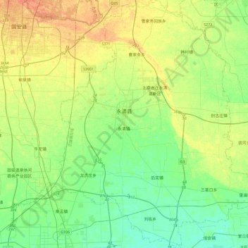
Name: Yongqing County topographic map, elevation, terrain.
Location: Yongqing County, Langfang City, Hebei, 065600, China (39.12605 116.37099 39.47750 116.74578)
Average elevation: 16 m
Minimum elevation: 4 m
Maximum elevation: 33 m
Thank you for supporting this site ❤️
Make a donation
Make a donation
Other topographic maps
Click on a map to view its topography, its elevation and its terrain.
Thank you for supporting this site ❤️
Make a donation
Make a donation
Thank you for supporting this site ❤️
Make a donation
Make a donation
Thank you for supporting this site ❤️
Make a donation
Make a donation
Thank you for supporting this site ❤️
Make a donation
Make a donation
Thank you for supporting this site ❤️
Make a donation
Make a donation
Thank you for supporting this site ❤️
Make a donation
Make a donation
Thank you for supporting this site ❤️
Make a donation
Make a donation