
Արտաշավան topographic map
Interactive map
Click on the map to display elevation.
About this map
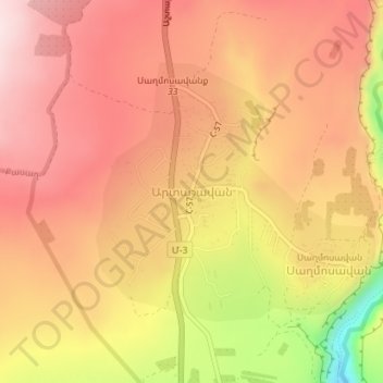
Name: Արտաշավան topographic map, elevation, terrain.
Location: Արտաշավան, Աշտարակի տարածաշրջան, Provinz Aragazotn, Armenien (40.37717 44.37228 40.39541 44.39076)
Average elevation: 1,629 m
Minimum elevation: 1,392 m
Maximum elevation: 1,747 m
Other topographic maps
Click on a map to view its topography, its elevation and its terrain.
Արտաշավան
Armenien > Provinz Aragazotn > Արտաշավան
Արտաշավան, Provinz Aragazotn, Armenien
Average elevation: 1,646 m