
Gedabek topographic map
Interactive map
Click on the map to display elevation.
About this map
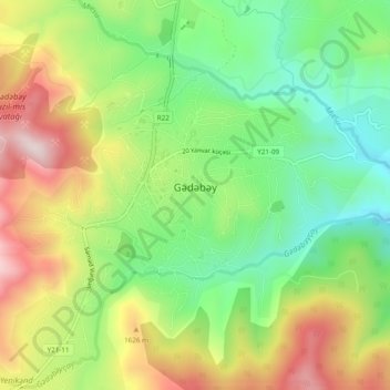
Name: Gedabek topographic map, elevation, terrain.
Location: Gedabek, Gedebey District, Qazakh-Tovuz, 2100, Azerbaijan (40.55978 45.79111 40.58655 45.83930)
Average elevation: 1,499 m
Minimum elevation: 1,289 m
Maximum elevation: 1,782 m
Gadabay lies at the northern foot of the Shahdagh Range, at an altitude of 1460 meters, on the coast of the Mis River. The city is located in the middle and high mountainous areas of the Lesser Caucasus (also called Little Caucasus).
Other topographic maps
Click on a map to view its topography, its elevation and its terrain.
Tovuz
Tovuz, Tovuz District, Qazakh-Tovuz, 6000, Azerbaijan
Average elevation: 429 m
Shamkir
Shamkir, Shamkir District, Qazakh-Tovuz, Azerbaijan
Average elevation: 579 m
Aghstafa District
Aghstafa District, Qazakh-Tovuz, 0500, Azerbaijan
Average elevation: 432 m
Qazax
Qazax, Qazakh District, Qazakh-Tovuz, Azerbaijan
Average elevation: 382 m