
Shamkir topographic map
Interactive map
Click on the map to display elevation.
About this map
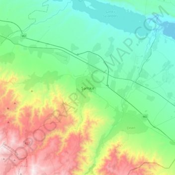
Name: Shamkir topographic map, elevation, terrain.
Location: Shamkir, Shamkir District, Qazakh-Tovuz, Azerbaijan (40.66952 45.86301 40.98952 46.18301)
Average elevation: 579 m
Minimum elevation: 100 m
Maximum elevation: 1,795 m
Other topographic maps
Click on a map to view its topography, its elevation and its terrain.
Gedabek
Gedabek, Gedebey District, Qazakh-Tovuz, 2100, Azerbaijan
Average elevation: 1,499 m
Tovuz
Tovuz, Tovuz District, Qazakh-Tovuz, 6000, Azerbaijan
Average elevation: 429 m
Aghstafa District
Aghstafa District, Qazakh-Tovuz, 0500, Azerbaijan
Average elevation: 432 m
Qazax
Qazax, Qazakh District, Qazakh-Tovuz, Azerbaijan
Average elevation: 382 m