
Gobustan District topographic map
Interactive map
Click on the map to display elevation.
About this map
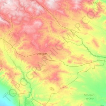
Name: Gobustan District topographic map, elevation, terrain.
Location: Gobustan District, Mountainous Shirvan, 3700, Azerbaijan (40.29368 48.69520 40.77506 49.30736)
Average elevation: 614 m
Minimum elevation: -2 m
Maximum elevation: 1,380 m
Other topographic maps
Click on a map to view its topography, its elevation and its terrain.
Şamaxı
Azerbaijan > Mountainous Shirvan
Şamaxı, Shamakhi District, Mountainous Shirvan, Azerbaijan
Average elevation: 724 m
Agsu District
Azerbaijan > Mountainous Shirvan
Agsu District, Mountainous Shirvan, Azerbaijan
Average elevation: 397 m
Ismailli District
Azerbaijan > Mountainous Shirvan
Ismailli District, Mountainous Shirvan, Azerbaijan
Average elevation: 1,009 m