
Şamaxı topographic map
Interactive map
Click on the map to display elevation.
About this map
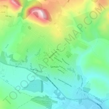
Name: Şamaxı topographic map, elevation, terrain.
Location: Şamaxı, Shamakhi District, Mountainous Shirvan, Azerbaijan (40.61684 48.61382 40.66020 48.65920)
Average elevation: 724 m
Minimum elevation: 580 m
Maximum elevation: 1,041 m
Other topographic maps
Click on a map to view its topography, its elevation and its terrain.
Agsu District
Azerbaijan > Mountainous Shirvan
Agsu District, Mountainous Shirvan, Azerbaijan
Average elevation: 397 m
Gobustan District
Azerbaijan > Mountainous Shirvan
Gobustan District, Mountainous Shirvan, 3700, Azerbaijan
Average elevation: 614 m
Ismailli District
Azerbaijan > Mountainous Shirvan
Ismailli District, Mountainous Shirvan, Azerbaijan
Average elevation: 1,009 m