
Kyrenia topographic map
Interactive map
Click on the map to display elevation.
About this map
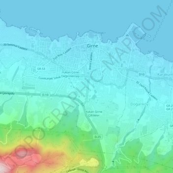
Name: Kyrenia topographic map, elevation, terrain.
Average elevation: 89 m
Minimum elevation: -1 m
Maximum elevation: 590 m
Another topographical source is the 'Stadiasmus Maris Magni' (from the name 'stadion', a unit measuring distances, 1 stadion = 184 metres). The unknown author, who sailed from Cape Anamur on the Cilician coast to Cyprus and circumnavigated the island, gave the distances from Asia Minor to the nearest point in Cyprus. This was 300 stadia, about 55 000 metres. He also recorded distances between towns. From Soli to Kyrenia he counted 350 stadia, from Kyrenia to Lapithos 50 and from Lapithos to Karpasia it was 550 stadia.
Other topographic maps
Click on a map to view its topography, its elevation and its terrain.
Karavas
Karavas, Lapta-Alsancak-Çamlıbel Belediyesi, Girne (Kyrenia) District, Northern Cyprus, Cyprus
Average elevation: 239 m