
Kerala topographic map
Interactive map
Click on the map to display elevation.
About this map
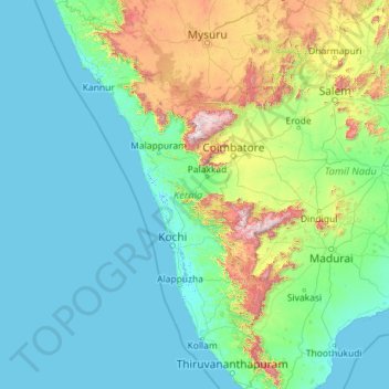
Name: Kerala topographic map, elevation, terrain.
Location: Kerala, India (8.29353 74.86407 12.79606 77.41236)
Average elevation: 251 m
Minimum elevation: -4 m
Maximum elevation: 2,557 m
Kerala was alternatively called Malabar in the foreign trade circles. Earlier, the term Malabar had also been used to denote Tulu Nadu and Kanyakumari which lie contiguous to Kerala on the southwestern coast of India, in addition to the modern state of Kerala. The people of Malabar were known as Malabars. Until the arrival of the East India Company, the term Malabar was used as a general name for Kerala, along with the term Kerala. From the time of Cosmas Indicopleustes (6th century CE) itself, the Arab sailors used to call Kerala as Male. The first element of the name, however, is attested already in the Topography written by Cosmas Indicopleustes. This mentions a pepper emporium called Male, which clearly gave its name to Malabar ('the country of Male'). The name Male is thought to come from the Malayalam word Mala ('hill'). Al-Biruni (973–1048 CE) is the first known writer to call this country Malabar. Authors such as Ibn Khordadbeh and Al-Baladhuri mention Malabar ports in their works. The Arab writers had called this place Malibar, Manibar, Mulibar, and Munibar. Malabar is reminiscent of the word Malanad which means the land of hills. According to William Logan, the word Malabar comes from a combination of the Malayalam word Mala (hill) and the Persian/Arabic word Barr (country/continent).
Other topographic maps
Click on a map to view its topography, its elevation and its terrain.
Hyderabad
India > Telangana > Bahadurpura mandal
Hyderabad, Bahadurpura mandal, Hyderabad District, Telangana, India
Average elevation: 549 m
Dehradun
India > Uttarakhand > Dehradun
Dehradun, Dehradun District, Uttarakhand, 248001, India
Average elevation: 904 m
Bhopal
India > Madhya Pradesh > Huzur Tahsil
Bhopal, Huzur Tahsil, Bhopal District, Madhya Pradesh, 462001, India
Average elevation: 498 m
Bengaluru
India > Karnataka > Bangalore North
Bengaluru, Bangalore North, Bengaluru Urban District, Karnataka, India
Average elevation: 881 m
Jite
India > Maharashtra > Mangaon
Jite, Mangaon, Raigad District, Maharashtra, India
Average elevation: 191 m
Mangaluru
India > Karnataka > Mangaluru taluk
Mangaluru, Mangaluru taluk, Dakshina Kannada District, Karnataka, 575001, India
Average elevation: 25 m
Madurai
India > Tamil Nadu > Madurai
Madurai, Madurai South, Madurai district, Tamil Nadu, India
Average elevation: 138 m
Baghpat
India > Uttar Pradesh > Baghpat
Baghpat, Baghpat District, Uttar Pradesh, 250609, India
Average elevation: 219 m
Pedda Arikatla
India > Andhra Pradesh > Konakanamitla
Pedda Arikatla, Konakanamitla, Prakasam, Andhra Pradesh, 523245, India
Average elevation: 119 m
Mandi
India > Himachal Pradesh > Mandi
Mandi, Mandi District, Himachal Pradesh, 175001, India
Average elevation: 1,273 m
Musi River
Musi River, Hyderabad, Uppal mandal, Medchal–Malkajgiri, Telangana, 5000036, India
Average elevation: 490 m
Lohar
India > Madhya Pradesh > Dewas Tahsil
Lohar, Dewas Tahsil, Dewas District, Madhya Pradesh, India
Average elevation: 522 m
Lonavala
India > Maharashtra > Mawal
Lonavala, Mawal, Pune, Maharashtra, 410400, India
Average elevation: 613 m
Udaipur
India > Rajasthan > Girwa Tehsil
Udaipur, Girwa Tehsil, Udaipur District, Rajasthan, 313001, India
Average elevation: 656 m
Chennai
India > Tamil Nadu > Chennai
Chennai, Chennai District, Tamil Nadu, India
Average elevation: 8 m
Siliguri
India > West Bengal > Siliguri Subdivsion
Siliguri, Siliguri Subdivsion, Darjeeling District, West Bengal, India
Average elevation: 121 m
Navi Mumbai
India > Maharashtra > Thane > Navi Mumbai
Navi Mumbai, Mumbai Metropolitan Region, Thane, Maharashtra, 400706, India
Average elevation: 30 m
Vadodara
India > Gujarat > Vadodara Taluka
Vadodara, Vadodara Taluka, Vadodara District, Gujarat, 390001, India
Average elevation: 36 m
Pune
India > Maharashtra > Pune City > Pune
Pune, Pune City, Pune District, Maharashtra, 411001, India
Average elevation: 641 m
Thanjavur
India > Tamil Nadu > Thanjavur
Thanjavur, Thanjavur District, Tamil Nadu, 613001, India
Average elevation: 49 m
Sakharwadi
India > Maharashtra > Badnapur
Sakharwadi, Badnapur, Jalna District, Maharashtra, India
Average elevation: 633 m
Ambaji
India > Gujarat > Danta Taluka
Ambaji, Danta Taluka, Banaskantha District, Gujarat, 385110, India
Average elevation: 453 m
Chhatri
India > Himachal Pradesh > Thunag
Chhatri, Thunag, Mandi District, Himachal Pradesh, India
Average elevation: 2,079 m
Sojha
India > Himachal Pradesh > Bali Chowki
Sojha, Bali Chowki, Mandi District, Himachal Pradesh, India
Average elevation: 2,325 m
Dasada
India > Gujarat > Dasada Taluka
Dasada, Dasada Taluka, Surendranagar District, Gujarat, 382750, India
Average elevation: 28 m
Asundi
India > Karnataka > Bellary taluk
Asundi, Bellary taluk, Ballari District, Karnataka, India
Average elevation: 419 m
Anaikatti
India > Tamil Nadu > Coimbatore North
Anaikatti, Mannarkad, Palakkad District, Kerala, 678741, India
Average elevation: 623 m