
Brazil topographic map
Interactive map
Click on the map to display elevation.
About this map
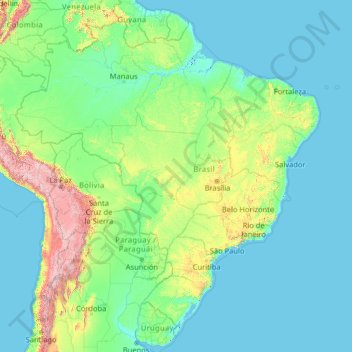
Name: Brazil topographic map, elevation, terrain.
Location: Brazil (-33.86891 -73.98306 5.26958 -28.62896)
Average elevation: 368 m
Minimum elevation: -2 m
Maximum elevation: 6,497 m
The climate of Brazil comprises a wide range of weather conditions across a large area and varied topography, but most of the country is tropical. According to the Köppen system, Brazil hosts six major climatic subtypes: desert, equatorial, tropical, semiarid, oceanic and subtropical. The different climatic conditions produce environments ranging from equatorial rainforests in the north and semiarid deserts in the northeast, to temperate coniferous forests in the south and tropical savannas in central Brazil. Many regions have starkly different microclimates.
Other topographic maps
Click on a map to view its topography, its elevation and its terrain.
India
India
Average elevation: 1,017 m
Hyderabad
India > Telangana > Bahadurpura mandal
Hyderabad, Bahadurpura mandal, Hyderabad District, Telangana, India
Average elevation: 549 m
Montreal
Canada > Quebec > Urban agglomeration of Montreal > Montreal
Montreal, Urban agglomeration of Montreal, Montreal (06), Quebec, H3B 1M7, Canada
Average elevation: 30 m
Sri Lanka
Sri Lanka
Average elevation: 50 m
Ooty Lake
India > Tamil Nadu > Udhagamandalam > Udhagamandalam
Ooty Lake, Udhagamandalam, The Nilgiris District, Tamil Nadu, 643001, India
Average elevation: 2,235 m
Snohomish County
Snohomish County, Washington, United States
Average elevation: 649 m
Thiruvananthapuram
India > Kerala > Thiruvananthapuram
Thiruvananthapuram, Thiruvananthapuram District, Kerala, 695001, India
Average elevation: 33 m
Bengaluru
India > Karnataka > Bangalore North
Bengaluru, Bangalore North, Bengaluru Urban District, Karnataka, India
Average elevation: 881 m
Dehradun
India > Uttarakhand > Dehradun
Dehradun, Dehradun District, Uttarakhand, 248001, India
Average elevation: 904 m
Hays County
United States of America > Texas
Hays County, Texas, United States of America
Average elevation: 285 m
Kandy
Kandy, Kandy District, Central Province, 20000, Sri Lanka
Average elevation: 621 m
Madurai
India > Tamil Nadu > Madurai
Madurai, Madurai South, Madurai district, Tamil Nadu, India
Average elevation: 138 m
Panvel
India > Maharashtra > Panvel > Panvel
Panvel, Raigad, Maharashtra, 410206, India
Average elevation: 75 m
Petrópolis
Brazil > Rio de Janeiro > Região Metropolitana do Rio de Janeiro
Petrópolis, Região Geográfica Imediata de Petrópolis, Região Metropolitana do Rio de Janeiro, Região Geográfica Intermediária de Petrópolis, Rio de Janeiro, Southeast Region, Brazil
Average elevation: 832 m
Delhi
India > Delhi > Kotwali Tehsil
Delhi, Kotwali Tehsil, Central Delhi, Delhi, 110006, India
Average elevation: 216 m
Pune
India > Maharashtra > Pune City > Pune
Pune, Pune City, Pune District, Maharashtra, 411001, India
Average elevation: 641 m
Nepal
Nepal
Average elevation: 2,604 m
Bondapalli
India > Andhra Pradesh > Bondapalle
Bondapalli, Bondapalle, Vizianagaram, Andhra Pradesh, 531260, India
Average elevation: 72 m
Bodhupatti
India > Tamil Nadu > Namakkal
Bodhupatti, Namakkal, Namakkal District, Tamil Nadu, 637002, India
Average elevation: 193 m
Central Camp
United States > California > Madera County
Central Camp, Madera County, California, United States
Average elevation: 1,745 m
Clappana
India > Kerala > Karunagappally
Clappana, Karunagappally, Kollam District, Kerala, 690525, India
Average elevation: 5 m
Tacoma
United States > Washington > Pierce County
Tacoma, Pierce County, Washington, United States
Average elevation: 67 m
Chennai
India > Tamil Nadu > Chennai
Chennai, Chennai District, Tamil Nadu, India
Average elevation: 8 m
Mangaluru
India > Karnataka > Mangaluru taluk
Mangaluru, Mangaluru taluk, Dakshina Kannada District, Karnataka, 575001, India
Average elevation: 25 m
Phuthaditjhaba
South Africa > Free State > Thabo Mofutsanyana District Municipality > Maluti-a-Phofung Local Municipality
Phuthaditjhaba, Maluti-a-Phofung Local Municipality, Thabo Mofutsanyana District Municipality, Free State, 9866, South Africa
Average elevation: 1,736 m
Kapugollewa
Sri Lanka > North Central Province
Kapugollewa, Anuradhapura District, North Central Province, Sri Lanka
Average elevation: 65 m
Kebitigollewa
Sri Lanka > North Central Province
Kebitigollewa, Anuradhapura District, North Central Province, Sri Lanka
Average elevation: 108 m
Uhana
Uhana, Ampara District, Eastern Province, Sri Lanka
Average elevation: 42 m
Namaloya
Namaloya, Ampara District, Eastern Province, Sri Lanka
Average elevation: 91 m
Kalmunai
Kalmunai, Ampara District, Eastern Province, 31300, Sri Lanka
Average elevation: 2 m
Akkaraipattu
Akkaraipattu, Ampara District, Eastern Province, 32400, Sri Lanka
Average elevation: 3 m
Malwaththai
Malwaththai, Ampara District, Eastern Province, Sri Lanka
Average elevation: 16 m