
Thank you for supporting this site ❤️
Make a donation
Make a donation
Musi River topographic map
Click on the map to display elevation.
Thank you for supporting this site ❤️
Make a donation
Make a donation
About this map
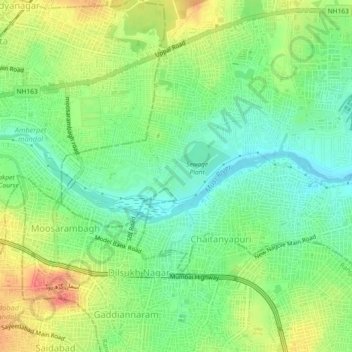
Name: Musi River topographic map, elevation, terrain.
Average elevation: 490 m
Minimum elevation: 466 m
Maximum elevation: 523 m
Thank you for supporting this site ❤️
Make a donation
Make a donation
Other topographic maps
Click on a map to view its topography, its elevation and its terrain.
Thank you for supporting this site ❤️
Make a donation
Make a donation
Greater Hyderabad Municipal Corporation Central Zone
India > Telangana > Hyderabad > Ramdev Guda
Average elevation: 520 m