Geolocate

Parambikulam topographic map

Interactive map

Click on the map to display elevation.

About this map

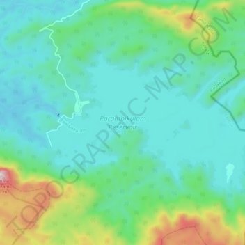
Name: Parambikulam topographic map, elevation, terrain.

Location: Parambikulam, Chittur, Palakkad district, Kerala, India (10.36147 76.76409 10.41028 76.85327)

Average elevation: 696 m

Minimum elevation: 499 m

Maximum elevation: 1,416 m

Other topographic maps

Click on a map to view its topography, its elevation and its terrain.

Chittur-Thathamangalam

India > Kerala > Chittur > Manchira

Chittur-Thathamangalam, Manchira, Chittur, Palakkad District, Kerala, India

Average elevation: 117 m

Nelliyampathy

India > Kerala > Chittur

Nelliyampathy, Chittur, Palakkad District, Kerala, India

Average elevation: 989 m

Meenkara Dam

India > Kerala > Chittur > Govindapuram

Meenkara Dam, Govindapuram, Chittur, Palakkad district, Kerala, 678507, India

Average elevation: 155 m