
Thiruverumbur topographic map
Interactive map
Click on the map to display elevation.
About this map
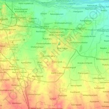
Name: Thiruverumbur topographic map, elevation, terrain.
Location: Thiruverumbur, Tiruchirappalli District, Tamil Nadu, India (10.64205 78.70837 10.83921 78.88052)
Average elevation: 80 m
Minimum elevation: 53 m
Maximum elevation: 114 m
Other topographic maps
Click on a map to view its topography, its elevation and its terrain.