
Shivpuri topographic map
Interactive map
Click on the map to display elevation.
About this map
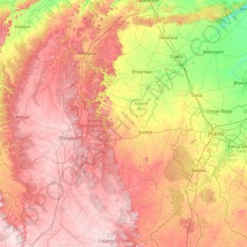
Name: Shivpuri topographic map, elevation, terrain.
Location: Shivpuri, Shivpuri district, Madhya Pradesh, India (24.80000 77.30000 26.20000 78.70000)
Average elevation: 328 m
Minimum elevation: 138 m
Maximum elevation: 525 m
Other topographic maps
Click on a map to view its topography, its elevation and its terrain.
Guna
Guna is located at 24.65°N 77.32°E.[1] It has an average elevation of 474 metres (1555 ft).
Average elevation: 434 m
Guna
Guna is located at 24.65°N 77.32°E.[1] It has an average elevation of 474 metres (1555 ft).
Average elevation: 434 m
Dewas
Due to its high elevation and inland location, even during the hottest months of the year, the nights are relatively cool, which is known as Shab-e-Malwa. Three distinct seasons are observed: summer, monsoon and winter. Dewas gets most of its rainfall during July–September due to the southwest monsoon.
Average elevation: 445 m