
Make a donation
West Nimār topographic map
Click on the map to display elevation.
Make a donation
About this map
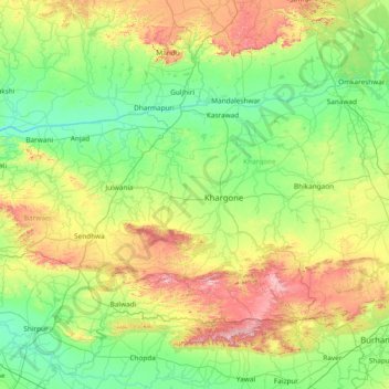
Name: West Nimār topographic map, elevation, terrain.
Location: West Nimār, Khargone, Madhya Pradesh, 451440, India (21.13333 74.80000 22.53333 76.20000)
Average elevation: 330 m
Minimum elevation: 111 m
Maximum elevation: 1,045 m
Make a donation
Other topographic maps
Click on a map to view its topography, its elevation and its terrain.
Make a donation
Make a donation
Make a donation
Make a donation
Make a donation
Make a donation
Make a donation
Make a donation
Make a donation
Make a donation
Make a donation
Make a donation
Narmadapuram
Pachmarhi is known for its natural environment, and lies at an altitude of 3,555 feet. It is surrounded by the Satpura hills. Satpura National Park and Madai Tiger Reserve are wildlife.
Average elevation: 458 m
Make a donation
Dewas
Due to its high elevation and inland location, even during the hottest months of the year, the nights are relatively cool, which is known as Shab-e-Malwa. Three distinct seasons are observed: summer, monsoon and winter. Dewas gets most of its rainfall during July–September due to the southwest monsoon.
Average elevation: 445 m
Make a donation
Make a donation
Make a donation
Make a donation
Rajgarh
The Newaj is left bank tributary of the river Parwan which is a right bank principal tributary of the Kalisindh. The Newaj River rises at an elevation of 634 m in the Astha tehsil of the Sehore district in Madhya Pradesh and traverses a total length of 220 km, out of which 205 km is in Madhya Pradesh. The…
Average elevation: 429 m
Chhindwara
The altitude of the district varies from 1,550 ft (470 m) to 3,820 ft (1,160 m) above sea level with an average elevation of 2215 feet (675 m).
Average elevation: 619 m
Make a donation
Make a donation
Make a donation
Make a donation
Make a donation
Make a donation
Make a donation
Make a donation