
Make a donation
Aguascalientes topographic map
Click on the map to display elevation.
Make a donation
Aguascalientes
Aguascalientes (Spanish pronunciation: [ˌaɣwaskaˈljentes] ; lit. 'Hot Springs'), officially the Free and Sovereign State of Aguascalientes (Spanish: Estado Libre y Soberano de Aguascalientes), is one of the 32 states which comprise the Federal Entities of Mexico. At 22°N and with an average altitude of 1,950 m (6,400 ft) above sea level it is predominantly of semi-arid climate (Bhs and Bhk). The state is located in west-central Mexico and is located in the northern part of the Bajío region, which is in the north-central part of the country, bordered by Zacatecas to the north, east and west, and by Jalisco to the south.
Make a donation
About this map
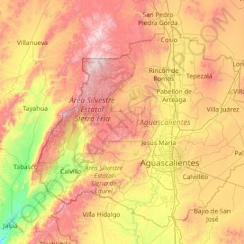
Name: Aguascalientes topographic map, elevation, terrain.
Location: Aguascalientes, Mexico (21.62227 -102.87418 22.45959 -101.83529)
Average elevation: 2,049 m
Minimum elevation: 1,339 m
Maximum elevation: 3,020 m
Make a donation
Other topographic maps
Click on a map to view its topography, its elevation and its terrain.
Paseo al Monte (Camino a la Boquilla)
Mexico > Zacatecas > Moyahua de Estrada > Moyahua de Estrada
Average elevation: 1,224 m
Make a donation
Make a donation
Texcoco de Mora
Mexico > State of Mexico > Texcoco
Tescoco lies about 25 km east of the centre of Mexico City. Major elevations in the municipality include the Tlaloc Mountain (4,500 meters) the Tetzcutzinco, Moyotepec and Tecuachacho. Most elevations are named after the major community to be found on them. There are also a number of small canyons. Part of the…
Average elevation: 2,262 m
Make a donation
Chihuahua
Mexico > Chihuahua > Municipio de Chihuahua
Chihuahua lies on the western side of the Chihuahuan Desert ecoregion and as such has a semiarid climate (Köppen climate classification BSh). However, it is not as hot as most of the lower elevated portions of the desert to the east owing to an altitude of almost 1,500 metres (4,900 feet) above sea level.
Average elevation: 1,555 m
Make a donation
Hecelchakán
Mexico > Campeche > Hecelchakán
It is at an altitude of 10 m above sea level.
Average elevation: 34 m
Make a donation
Ciudad Victoria
Mexico > Tamaulipas > Victoria
Ciudad Victoria has a climate on the border of humid subtropical (Köppen Cfa/Cwa) and hot semi-arid (BSh). Its weather is characterised by short warm winters and long hot to sweltering summers. Temperatures rarely drop below 0 °C (32 °F) — the lowest recorded temperature was −6 °C (21.2 °F) and the…
Average elevation: 518 m
Make a donation
Aguascalientes
Mexico > Aguascalientes > Municipio de Aguascalientes
The Aguascalientes Bicentenary Velodrome, designed by Peter Junek, hosted the 2010 Pan American Track Championships. At an elevation of 1887m, the Velodrome is a frequent location for attempts at breaking the Cycling Hour Record.
Average elevation: 1,956 m
Make a donation
Make a donation
Piedras Negras
Mexico > Coahuila > Municipio de Piedras Negras > Piedras Negras
Average elevation: 256 m
Make a donation