
North Western Province topographic map
Interactive map
Click on the map to display elevation.
About this map
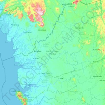
Name: North Western Province topographic map, elevation, terrain.
Location: North Western Province, Sierra Leone (8.25979 -13.49578 9.94018 -11.87306)
Average elevation: 92 m
Minimum elevation: -2 m
Maximum elevation: 1,186 m
Other topographic maps
Click on a map to view its topography, its elevation and its terrain.
Mankara
Sierra Leone > North Western Province > Mankara
Mankara, Kambia District, North Western Province, Sierra Leone
Average elevation: 15 m