
Alwar topographic map
Interactive map
Click on the map to display elevation.
About this map
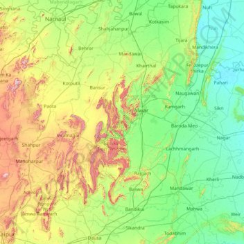
Name: Alwar topographic map, elevation, terrain.
Location: Alwar, Alwar District, Rajasthan, India (26.80000 75.80000 28.20000 77.20000)
Average elevation: 326 m
Minimum elevation: 181 m
Maximum elevation: 820 m
Other topographic maps
Click on a map to view its topography, its elevation and its terrain.
Haldighati Park
India > Rajasthan > Sanganer Tehsil > Jaipur Municipal Corporation
Average elevation: 372 m
Hindaun
India > Rajasthan > Hindaun Tehsil
Hindaun has an average elevation of 235 metres (771 ft). Its distance from the state capital of Jaipur is around 150 km.
Average elevation: 230 m
Padampur
India > Rajasthan > Padampur Tehsil
Located in southwest of the Ganganagar district, the city has an average elevation of 165 metres (541 ft)
Average elevation: 169 m
Pratapgarh
Pratapgarh is located at 24.03° N 74.78° E with an average elevation of 580 meters (1610 feet above mean sea level). It is said to be the second highest place (?) in Rajasthan after Mount Abu. Situated on the junction of the Aravali mountain ranges and the Malwa Plateau its unique location prominently…
Average elevation: 390 m
Pokaran
India > Rajasthan > Pokaran Tehsil
Pokhran is located 112 km east of Jaisalmer city, 172 km northwest of Jodhpur and 225 km south of Bikaner by road. It lies on Jaisalmer to Jodhpur railway line. It is situated at 27°05′42″N 71°45′11″E / 27.095°N 71.753°E / 27.095; 71.753 and has an average elevation of 233 metres (764 feet).
Average elevation: 229 m
Dausa
The general topographic elevation in the district is between 250 m to 300 m above sea level. Elevation ranges from a minimum of 203.2 m above sea level in Mahwa in the northeastern part of the district and maximum of 596.3 m above sea level in Bandikui in northern part of the district.
Average elevation: 313 m
Haldighati Park
India > Rajasthan > Sanganer Tehsil > Jaipur Municipal Corporation
Average elevation: 372 m
Jodhpur District
The district is located in the State of Rajasthan in western India. The district is bounded on the north by Bikaner District, on the northeast by Nagaur District, on the southeast and south by Pali District, on the southwest by Barmer District, and on the west and northwest by Jaisalmer District. The district…
Average elevation: 228 m
karauli
India > Rajasthan > Karauli Tehsil
Karauli is located at 26°30′N 77°01′E / 26.5°N 77.02°E / 26.5; 77.02. It has an average elevation of 275 metres (902 ft).
Average elevation: 273 m
Ranvir shekhawat park
India > Rajasthan > Sanganer Tehsil > Jaipur Municipal Corporation
Average elevation: 413 m
Kumbhalgarh Fort
India > Rajasthan > Kumbhalgarh Tehsil > Quila Kumbhalgarh > Aret
Average elevation: 876 m
Pali
The Aravalli Range forms the eastern boundary of the district, and the southern boundary ends at Bamnera village in Sumerpur Tehsil. There are foothills to the west, through which run some Luni River tributaries. The western portion of the district includes the alluvial plain of the Luni. The district is…
Average elevation: 351 m
Sirohi
Sirohi District is broken up by hills and rocky ranges. The granite massif of Mount Abu divides the district into two portions, running from north-east to south-west. The south and south-east part of the district, which lies between Mount Abu and the main spine of the Aravallis, is mountainous and rugged, and…
Average elevation: 351 m
Pali
The Aravalli Range forms the eastern boundary of the district; the southern boundary ends at Bamnera village in Sumerpur Tehsil. A zone of foothills lies to the west, through which run the many tributaries of the Luni River. The western portion of the district includes the alluvial plain of the Luni. It is…
Average elevation: 377 m
Jaipur Municipal Corporation
India > Rajasthan > Jaipur Municipal Corporation
Average elevation: 411 m