
Make a donation
Western Province topographic map
Click on the map to display elevation.
Make a donation
About this map
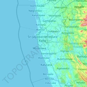
Name: Western Province topographic map, elevation, terrain.
Location: Western Province, Sri Lanka (6.32486 79.61616 7.33053 80.38127)
Average elevation: 140 m
Minimum elevation: -1 m
Maximum elevation: 2,168 m
Make a donation
Other topographic maps
Click on a map to view its topography, its elevation and its terrain.
Kandy
Kandy is located in the mountainous and thickly forested interior of the island. The city is located in between multiple mountain ranges including the Knuckles mountain range and the Hanthana Mountain Range, giving the city an elevation of 500 metres (1,600 ft) above sea level. It lies adjacent to the…
Average elevation: 621 m
Make a donation
Make a donation
Make a donation
Make a donation
Make a donation
Ella
Ella (Sinhala: ඇල්ල, lit. 'fall'; Tamil: எல்ல) is a small town in the Badulla District of Uva Province, Sri Lanka governed by an Urban Council. It is approximately 200 kilometres (120 mi) east of Colombo and is situated at an elevation of 1,041 metres (3,415 ft) above sea level. The area has…
Average elevation: 1,021 m
Make a donation
Make a donation
Make a donation
Make a donation
Make a donation
Make a donation
Mirissa
Mirissa (Sinhala: මිරිස්ස, romanized: Mirissa; Tamil: மிரிஸ்ஸ, romanized: Miris'sa) is a small town on the south coast of Sri Lanka, located in the Matara District of the Southern Province. It is approximately 150 kilometres (93 mi) south of Colombo and is situated at an elevation…
Average elevation: 4 m
Make a donation
Belihuloya
Sri Lanka > Sabaragamuwa Province
Belihuloya is a village in the Ratnapura District, Sabaragamuwa Province of Sri Lanka. It is approximately 150 kilometres (93 mi) south-east of Colombo and is situated at an elevation of 616 metres (2,021 ft) above sea level. This hillside location is a climatically transitional area, linking both the dry and…
Average elevation: 705 m
Gampola
Gampola, or so called Gangasiripura because of the Mahaweli (Mahaweli Ganga) flowing by its side, is a town which is located at an altitude of 300–500 m (980–1,640 ft), situated in a valley surrounded by hills and located near to Kandy. Geologically the region belongs to the Highland Complex of Sri Lanka…
Average elevation: 604 m
Make a donation
Hatton
Hatton is located approximately 112 km (70 mi) southeast of Colombo and 72 km (45 mi) south of Kandy, at an elevation of 1,271 m (4,170 ft) above sea level.
Average elevation: 1,290 m
Make a donation
Make a donation
Make a donation
Make a donation
Make a donation
Make a donation
Make a donation
Bentota
Bentota is a coastal town in Sri Lanka, located in the Galle District of the Southern Province. It is approximately 65 kilometres (40 mi) south of Colombo and 56 kilometres (35 mi) north of Galle. Bentota is situated on the southern bank of the Bentota River mouth, at an elevation of 3 metres (9.8 ft) above…
Average elevation: 2 m
Make a donation
Pussellawa
The beginning of the Hill country, Pussellawa is 16 km from Gampola on A5 Nuwara Eliya road and has an elevation of nearly 2,800 feet (850 m) that makes the climate cool and surroundings can go under the mist during late evenings. Pussellawa Rest House was a popular stop with the early travellers, who rested…
Average elevation: 985 m
Make a donation
Ahungalla
Ahungalla is a small coastal town, located in Galle District, Southern Province, Sri Lanka, governed by an Urban Council. It is approximately 76.6 kilometres (47.6 mi) south of Colombo and is situated at an elevation of 12 metres (39 ft) above the sea level.
Average elevation: 4 m
Hurulu Wewa Project Canel
Sri Lanka > North Central Province > Huruluwewa Left
Average elevation: 127 m
Make a donation
Make a donation
Make a donation