
Moratuwa topographic map
Click on the map to display elevation.
About this map
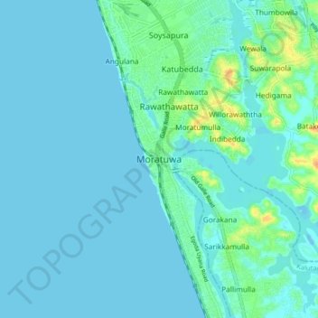
Name: Moratuwa topographic map, elevation, terrain.
Location: Moratuwa, Colombo District, Western Province, 10400, Sri Lanka (6.61468 79.72261 6.93468 80.04261)
Average elevation: 7 m
Minimum elevation: -2 m
Maximum elevation: 120 m
Other topographic maps
Click on a map to view its topography, its elevation and its terrain.
Seethawaka Export Processing Zone
Sri Lanka > Western Province > Avissawella > Seethawaka
Average elevation: 33 m
Uyanwatta Lake
Sri Lanka > Western Province > Bandaragama DS Division > Gelanigama
Average elevation: 16 m
Wevita Lake
Sri Lanka > Western Province > Bandaragama DS Division > Bandaragama
Average elevation: 9 m