
Pollachi topographic map
Interactive map
Click on the map to display elevation.
Pollachi
Pollachi is located at 10°39′43″N 77°00′23″E / 10.662°N 77.0065°E / 10.662; 77.0065. It has an average elevation of 293 metres (961 ft). Aliyar river passes about 10 kilometres (6.2 mi) away from the town and the town receives rainfall from Southwest monsoon due to the presence of Palghat gap.
About this map
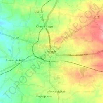
Name: Pollachi topographic map, elevation, terrain.
Location: Pollachi, Coimbatore, Tamil Nadu, 642001, India (10.61882 76.96873 10.69882 77.04873)
Average elevation: 289 m
Minimum elevation: 239 m
Maximum elevation: 350 m
Other topographic maps
Click on a map to view its topography, its elevation and its terrain.