
Kottur topographic map
Click on the map to display elevation.
About this map
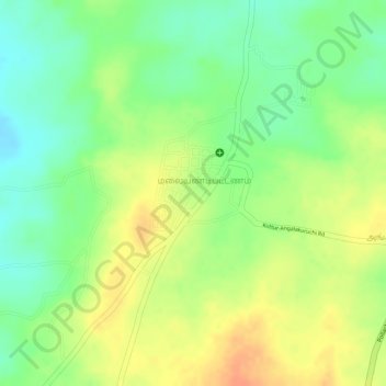
Name: Kottur topographic map, elevation, terrain.
Location: Kottur, Pollachi, Coimbatore District, Tamil Nadu, India (10.52596 76.97370 10.54753 76.98584)
Average elevation: 296 m
Minimum elevation: 273 m
Maximum elevation: 317 m
Other topographic maps
Click on a map to view its topography, its elevation and its terrain.
Pollachi
India > Tamil Nadu > Pollachi
Pollachi is located at 10°39′43″N 77°00′23″E / 10.662°N 77.0065°E / 10.662; 77.0065. It has an average elevation of 293 metres (961 ft). Aliyar river passes about 10 kilometres (6.2 mi) away from the town and the town receives rainfall from Southwest monsoon due to the presence of Palghat gap.
Average elevation: 289 m
Pollachi
India > Tamil Nadu > Pollachi
Pollachi is located at 10°39′43″N 77°00′23″E / 10.662°N 77.0065°E / 10.662; 77.0065 near the center of the South Indian Peninsula, surrounded by Western Ghats. It has an average elevation of 293 metres (961 ft) on the banks of Aliyar river. The area is hilly and rocky, drained by several…
Average elevation: 289 m