
Ghaziabad topographic map
Interactive map
Click on the map to display elevation.
About this map
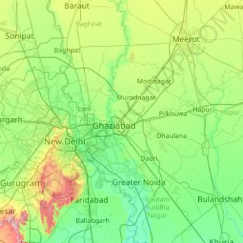
Name: Ghaziabad topographic map, elevation, terrain.
Location: Ghaziabad, Uttar Pradesh, India (28.62218 77.19924 28.92778 77.70953)
Average elevation: 216 m
Minimum elevation: 198 m
Maximum elevation: 243 m
Other topographic maps
Click on a map to view its topography, its elevation and its terrain.
Lucknow
India > Uttar Pradesh > Lucknow
Lucknow stands at an elevation of approximately 123 metres (404 ft) above sea level. The city had an area of 402 km2 (155 square miles) until December 2019, when 88 villages were added to the municipal limits and the area increased to 631 km2 (244 square miles). Bounded on the east by Barabanki, on the west by…
Average elevation: 120 m
Varanasi
India > Uttar Pradesh > Sadar
Varanasi is located at an elevation of 80.71 metres (264.8 ft) in the centre of the Ganges valley of North India, in the Eastern part of the state of Uttar Pradesh, along the left crescent-shaped bank of the Ganges, averaging between 15 metres (50 ft) and 21 metres (70 ft) above the river. The city is the…
Average elevation: 77 m
Ayodhya
India > Uttar Pradesh > Faizabad
The earliest of the Buddhist Pali-language texts and the Jain Prakrit-language texts mention a city called Saketa (Sageya or Saeya in Prakrit) as an important city of the Kosala mahajanapada. Topographical indications in both Buddhist and Jain texts suggest that Saketa is the same as the present-day Ayodhya.…
Average elevation: 96 m
Lucknow
India > Uttar Pradesh > Lucknow
The city stands at an elevation of approximately 123 metres (404 ft) above sea level. Lucknow city had an area of 402 km2 (155 square miles) till December 2019, when 88 villages were added to the municipal limits and the area increased to 631 km2 (244 square miles). Bounded on the east by Barabanki, on the…
Average elevation: 120 m
Mirzapur
India > Uttar Pradesh > Mirzapur
Mirzapur is located at 25°09′N 82°35′E / 25.15°N 82.58°E / 25.15; 82.58. It has an average elevation of 80 metres (265 feet). The District of Mirzapur lies between the parallels of 23.52 & 25.32 North latitude and 82.7 and 83.33 East longitude. It forms a portion of the Varanasi district. On…
Average elevation: 83 m
Ghazipur
India > Uttar Pradesh > Ghazipur
Ghazipur is located at 25°35′N 83°34′E / 25.58°N 83.57°E / 25.58; 83.57. It has an average elevation of 62 metres (203 feet).
Average elevation: 68 m
Ayodhya
India > Uttar Pradesh > Faizabad
The earliest of the Buddhist Pali-language texts and the Jain Prakrit-language texts mention a city called Saketa (Sageya or Saeya in Prakrit) as an important city of the Kosala mahajanapada. Topographical indications in both Buddhist and Jain texts suggest that Saketa is the same as the present-day Ayodhya.…
Average elevation: 96 m
Dudhwa National Park
India > Uttar Pradesh > Palia
Dudhwa National Park is located in Lakhimpur Kheri district of Uttar Pradesh. The area of the park falls within the Upper Gangetic plains and is a vast alluvial plain ranging in elevation from 150 m (490 ft) in the farthest southeast to 182 m (597 ft) in the north.
Average elevation: 163 m
Prayagraj
India > Uttar Pradesh > Prayagraj
Prayagraj's elevation is over 90 m (295 ft) above sea level. The old part of the city, at the south of Prayagraj Junction railway station, consists of neighbourhoods like Chowk, Johnstongunj, Dariyabad, Khuldabad and many more. In the north of the Railway Station, the new city consists of neighbourhoods like…
Average elevation: 91 m
Lucknow
India > Uttar Pradesh > Lucknow
Lucknow stands at an elevation of approximately 123 metres (404 ft) above sea level. The city had an area of 402 km2 (155 square miles) until December 2019, when 88 villages were added to the municipal limits and the area increased to 631 km2 (244 square miles).
Average elevation: 120 m
Shikohabad
India > Uttar Pradesh > Shikohabad
Shikohabad is located at 27°06′N 78°36′E / 27.1°N 78.6°E / 27.1; 78.6. It has an average elevation of 163 m (535 ft). The river Sirsa flows between the main city and pass out the railway station.
Average elevation: 160 m
Okhla Bird Sanctuary
India > Uttar Pradesh > Defence Colony Tehsil > Noida > Dadri
Average elevation: 201 m
Sahaspur
India > Uttar Pradesh > Dhampur
Sahaspur has an average elevation of 199 metres (653 feet).
Average elevation: 217 m
Lucknow
India > Uttar Pradesh > Lucknow
The city stands at an elevation of approximately 123 metres (404 ft) above sea level. Lucknow city had an area of 402 km2 (155 square miles) till December 2019, when 88 villages were added to the municipal limits and the area increased to 631 km2 (244 square miles). Bounded on the east by Barabanki, on the…
Average elevation: 120 m
Varanasi
India > Uttar Pradesh > Sadar
Varanasi is located at an elevation of 80.71 metres (264.8 ft) in the centre of the Ganges valley of North India, in the Eastern part of the state of Uttar Pradesh, along the left crescent-shaped bank of the Ganges, averaging between 15 metres (50 ft) and 21 metres (70 ft) above the river. The city is the…
Average elevation: 77 m
Mahoba
India > Uttar Pradesh > Mahoba
Mahoba is located at 25°17′N 79°52′E / 25.28°N 79.87°E / 25.28; 79.87. It has an average elevation of 214 metres (702 feet).
Average elevation: 208 m
Unnao
India > Uttar Pradesh > Unnao
Unnao lies in the great plains of the Ganges and hence the land is highly fertile. The soil is mostly alluvial. The Ganges separates Unnao from Kanpur district. The district is bounded by river Ganges in the west and the river Sai in the east. The entire district falling in Sai Sub-basin of the Ganges basin…
Average elevation: 123 m
Sultanpur
India > Uttar Pradesh > Sultanpur
Sultanpur has an average elevation of 95 metres (312 ft). The geography of Sultanpur comprises plain lands, except for some regions around the Gomti River, which drains almost the whole city and district. The southern part of the city drains towards the Sai River flowing through the Pratapgarh district. The…
Average elevation: 97 m
Kannauj
India > Uttar Pradesh > Kannauj
Kannauj is located at 27°04′N 79°55′E / 27.07°N 79.92°E / 27.07; 79.92. It has an average elevation of 139 metres (456 feet).
Average elevation: 135 m
Charkhari
India > Uttar Pradesh > Charkhari
Charkhari is located at 25°24′N 79°45′E / 25.4°N 79.75°E / 25.4; 79.75. It has an average elevation of 184 metres (603 feet). Charkhari is also known as the 'Kashmir of Bundelkhand'. The town is surrounded by many lakes. There are lakes named Vijay Sagar, Malkhan Sagar, Vanshi Sagar, Jai…
Average elevation: 185 m
Varanasi
India > Uttar Pradesh > Sadar
Varanasi is located at an elevation of 80.71 metres (264.8 ft) in the centre of the Ganges valley of North India, in the Eastern part of the state of Uttar Pradesh, along the left crescent-shaped bank of the Ganges, averaging between 15 metres (50 ft) and 21 metres (70 ft) above the river. The city is the…
Average elevation: 77 m
Hardoi
India > Uttar Pradesh > Hardoi
Hardoi is located at 27°25′N 80°07′E / 27.42°N 80.12°E / 27.42; 80.12. It has an average elevation of 134 metres (440 ft). Hardoi is located 110 km from Lucknow (capital of Uttar Pradesh) and 394 from New Delhi (capital of India). The Ganges and several of its tributaries are crossing the…
Average elevation: 141 m
Lakhimpur
India > Uttar Pradesh > Lakhimpur
Lakhimpur is located at 27°57′N 80°46′E / 27.95°N 80.77°E / 27.95; 80.77. It has an average elevation of 147 metres (482 ft).
Average elevation: 141 m
Chandauli
India > Uttar Pradesh > Chandauli
Chandauli is located at 25°16′N 83°16′E / 25.27°N 83.27°E / 25.27; 83.27. It has an average elevation of 70 metres (230 ft). Located about 30 kilometers from Varanasi, it comes under Varanasi division of Uttar Pradesh. Mughalsarai, a major railway junction between northern and eastern India is…
Average elevation: 76 m
Lucknow
India > Uttar Pradesh > Lucknow
Lucknow stands at an elevation of approximately 123 metres (404 ft) above sea level. The city had an area of 402 km2 (155 square miles) until December 2019, when 88 villages were added to the municipal limits and the area increased to 631 km2 (244 square miles).
Average elevation: 120 m