
Make a donation
Mahesana topographic map
Click on the map to display elevation.
Make a donation
About this map
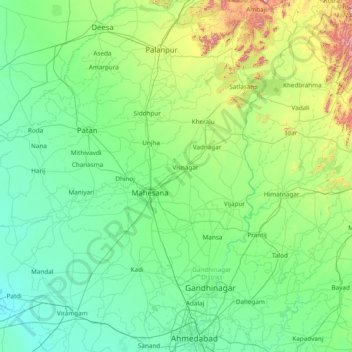
Name: Mahesana topographic map, elevation, terrain.
Location: Mahesana, Mahesana District, Gujarat, India (22.96667 71.80000 24.36667 73.20000)
Average elevation: 128 m
Minimum elevation: 5 m
Maximum elevation: 880 m
Make a donation
Other topographic maps
Click on a map to view its topography, its elevation and its terrain.
Make a donation
Make a donation
Make a donation
Palanpur
India > Gujarat > Palanpur Taluka
Palanpur is located at 24°06′N 72°15′E / 24.10°N 72.25°E / 24.10; 72.25. It has an average elevation of 209 metres (685 ft).
Average elevation: 218 m
Make a donation
Make a donation
Make a donation
Make a donation
Make a donation
Make a donation
Make a donation
Make a donation
Make a donation
Make a donation
Make a donation
Make a donation
Make a donation
Make a donation
Make a donation
Make a donation
Make a donation
Make a donation
Make a donation
Dhrangadhra
India > Gujarat > Dhrangadhra Taluka
Dhrangadhra is located at 22°59′N 71°28′E / 22.98°N 71.47°E / 22.98; 71.47. It has an average elevation of 64 metres (209 feet).
Average elevation: 52 m
Make a donation
Make a donation
Palanpur
India > Gujarat > Palanpur Taluka
Palanpur is located at 24°06′N 72°15′E / 24.10°N 72.25°E / 24.10; 72.25. It has an average elevation of 209 metres (685 ft).
Average elevation: 218 m
Make a donation