
Nalgonda topographic map
Interactive map
Click on the map to display elevation.
About this map
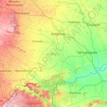
Name: Nalgonda topographic map, elevation, terrain.
Location: Nalgonda, Telangana, India (16.35570 78.61529 17.36021 79.70200)
Average elevation: 261 m
Minimum elevation: 39 m
Maximum elevation: 756 m
Other topographic maps
Click on a map to view its topography, its elevation and its terrain.
Kalkoda
India > Telangana > Marpalle mandal
Kalkoda is located at 17°28′31″N 77°43′34″E / 17.475388°N 77.726030°E / 17.475388; 77.726030. It has an average elevation of 617 metres (2027 ft).
Average elevation: 590 m
Adilabad
India > Telangana > Adilabad Urban Mandal
Adilabad has an average elevation of 264 metres. The district shares its boundaries with Nirmal districts of Telangana to the south, Komaram Bheem district on the east, with Nanded on the west and Yavatmal and Chandrapur districts of Maharashtra to the north.
Average elevation: 310 m
Sitha Vanigudem
India > Telangana > B. Pochampally mandal > Bhoodan Pochampally
Average elevation: 391 m
Aleru
India > Telangana > Alair mandal
Aler is located at 17°39′00″N 79°03′00″E / 17.6500°N 79.0500°E / 17.6500; 79.0500. It has an average elevation of 361 meters (1187 ft).
Average elevation: 370 m
Chandur
India > Telangana > Chandur mandal
Chandur is located at 16°59′N 79°04′E / 16.98°N 79.06°E / 16.98; 79.06. It has an average elevation of 484 metres (1587 feet).
Average elevation: 256 m
Warangal
India > Telangana > Warangal mandal
Warangal is located at 18°00′N 79°35′E / 18.0°N 79.58°E / 18.0; 79.58. It has an average elevation of 302 metres (990 feet). It is settled in the eastern part of Deccan Plateau made up of granite rocks and hill formations which left the region barren making the cultivation dependent on…
Average elevation: 268 m