
Panna topographic map
Interactive map
Click on the map to display elevation.
About this map
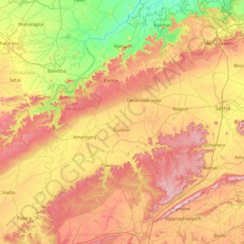
Name: Panna topographic map, elevation, terrain.
Location: Panna, Panna District, Madhya Pradesh, 488058, India (23.80000 79.55000 25.20000 80.95000)
Average elevation: 336 m
Minimum elevation: 110 m
Maximum elevation: 668 m
Other topographic maps
Click on a map to view its topography, its elevation and its terrain.
Dewas
Due to its high elevation and inland location, even during the hottest months of the year, the nights are relatively cool, which is known as Shab-e-Malwa. Three distinct seasons are observed: summer, monsoon and winter. Dewas gets most of its rainfall during July–September due to the southwest monsoon.
Average elevation: 445 m
Ashoknagar
Ashoknagar is situated at the average elevation of 507 metres(1640 ft) above sea level. It is in the plateau region. It has an agricultural topography. The plateau is an extension of the Deccan Traps, formed between 60 and 68 million years ago at the end of the Cretaceous period. In this region, the main…
Average elevation: 447 m
Morena
Morena is located at 26.5°N 78.0°E. It has an average elevation of 177 metres (580 feet). Its major rivers include the Chambal, Kwari, Asan, and Sank.
Average elevation: 226 m