
Make a donation
Nashik topographic map
Click on the map to display elevation.
Make a donation
About this map
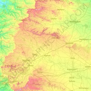
Name: Nashik topographic map, elevation, terrain.
Location: Nashik, Maharashtra, India (19.51667 73.38333 20.91667 74.78333)
Average elevation: 555 m
Minimum elevation: 72 m
Maximum elevation: 1,562 m
Make a donation
Other topographic maps
Click on a map to view its topography, its elevation and its terrain.
Mumbai
India > Maharashtra > Mumbai
Mumbai is on a narrow peninsula on the southwest of Salsette Island, which lies between the Arabian Sea to the west, Thane Creek to the east and Vasai Creek to the north. Mumbai's suburban district occupies most of the island. Navi Mumbai is east of Thane Creek and Thane is north of Vasai Creek. Mumbai…
Average elevation: 18 m
Pune
Pune is situated at approximately 18° 32" north latitude and 73° 51" east longitude. The city's total area is 15.642 km2, and the municipal corporation area covers 518 km2. By road Pune is 149 km (93 mi) south-east of Mumbai, 580 km (360 mi) south-west of Indore, 695 km (432 mi) west of Nagpur, 1,173 km (729…
Average elevation: 616 m
Mumbai
Mumbai is on a narrow peninsula on the southwest of Salsette Island, which lies between the Arabian Sea to the west, Thane Creek to the east and Vasai Creek to the north. Mumbai's suburban district occupies most of the island. Navi Mumbai is east of Thane Creek and Thane is north of Vasai Creek. Mumbai…
Average elevation: 18 m
Make a donation
Pune City
Pune lies on the western margin of the Deccan plateau, at an altitude of 560 m (1,840 ft) above sea level. It is on the leeward side of the Sahyadri mountain range, which forms a barrier from the Arabian Sea. It is a hilly city, with Vetal Hill rising to 800 m (2,600 ft) above sea level. The Sinhagad fort is…
Average elevation: 616 m
Make a donation
Navi Mumbai
India > Maharashtra > Thane Subdistrict
Navi Mumbai (Marathi pronunciation: [nəʋiː mumbəiː]), is a planned city situated on the west coast of the Indian subcontinent, located in the Konkan division of Maharashtra state, on the mainland of India. Navi Mumbai is part of the Mumbai Metropolitan Region (MMR). The city is divided into two, North…
Average elevation: 22 m
Panhala
Panhala is located at 16°49′12″N 74°7′12″E / 16.82000°N 74.12000°E / 16.82000; 74.12000. It has an average elevation of 754 metres (2473 feet). Panhala is connected via train and bus to Kolhapur and Sangli. Kolhapur is about 21 km away while Sangli is about 60 km. Kolhapur Chhatrapati…
Average elevation: 620 m
Make a donation
Nashik District
The entire Nashik district is underlain by the basaltic lava flows. These flows are normally horizontally disposed over a wide stretch and give rise to table land type of topography also known as a plateau. These flows occur in layered sequences and represented by massive unit at the bottom and vesicular unit…
Average elevation: 522 m
Make a donation
Nanded District
Nanded is bounded on the north by Yavatmal district of the Vidarbha region, with Latur on south-west, Parbhani and Hingoli districts on the west. On the eastern side lies Adilabad, Nirmal, Nizamabad and Kamareddy districts of Telangana state, and on the south lies Bidar of Karnataka state. The area presents…
Average elevation: 432 m
Paithan
Paithan is located at 19°29′N 75°23′E / 19.48°N 75.38°E / 19.48; 75.38. It has an average elevation of 458 m (1,503 ft).
Average elevation: 495 m
Make a donation
Make a donation
Make a donation
Make a donation
Pune City
Pune lies on the western margin of the Deccan plateau, at an altitude of 560 m (1,840 ft) above sea level. It is on the leeward side of the Sahyadri mountain range, which forms a barrier from the Arabian Sea. It is a hilly city, with Vetal Hill rising to 800 m (2,600 ft) above sea level. The Sinhagad fort is…
Average elevation: 616 m
Make a donation
Make a donation
Make a donation
Baramati
Baramati Tehsil is located in Western Maharashtra. It belongs to Pune Division. It is located 100 km towards east from district headquarters Pune. 240 km from state capital Mumbai towards east. Baramati tehsil has its head quarter that is Baramati town. Baramati tehsil lies between 18º04΄ to 18°32΄ north…
Average elevation: 582 m
Bramhapuri Town
India > Maharashtra > Brahmapuri Taluka
Bramhapuri is one of the six divisions located in the northeastern part of Chandrapur district, Maharashtra at 20°22′N 79°31′E / 20.36°N 79.51°E / 20.36; 79.51 and has an average elevation of 229.5 metres (753 feet). The town is located in the 73rd Vidhan Sabha constituency in Maharashtra.
Average elevation: 226 m
Make a donation
Make a donation
Pune District
The district is surrounded by Thane district on the northwest, Raigad district on the west, Satara district on the south, Solapur district on the southeast, and Ahmednagar district on the north and northeast. On the leeward side of the Western Ghats, it extends to the Deccan Plateau on the east. Pune is at an…
Average elevation: 520 m
Make a donation
Ratnagiri
An outstanding feature of the geography of the district is its uneven or hill topography, with about 45% of the district being characterized as 'hilly'. Very narrow riverine plains fringe the coastline.
Average elevation: 301 m
Make a donation
Make a donation
Make a donation
Make a donation
Make a donation
Paithan
Paithan is located at 19°29′N 75°23′E / 19.48°N 75.38°E / 19.48; 75.38. It has an average elevation of 458 m (1,503 ft).
Average elevation: 495 m
Make a donation
Make a donation
Latur District
Latur district is in the Marathwada region in Maharashtra in India, located between 17°52' North to 18°50' North and 76°18' East to 79°12' East in the Deccan plateau. It has an average elevation of 631 metres (2,070 ft) above mean sea level. The entire district of Latur is on the Balaghat plateau, 540 to…
Average elevation: 590 m
Make a donation
Make a donation
Make a donation
Make a donation