Geolocate

Pathanamthitta topographic map

Click on the map to display elevation.

Pathanamthitta

Pathanamthitta has an average elevation of 18 metres (62 ft) above sea level.

Wikipedia (CC-BY-SA 3.0)

About this map

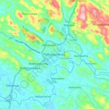
Name: Pathanamthitta topographic map, elevation, terrain.

Location: Pathanamthitta, Kozhencherry, Pathanamthitta District, Kerala, 689671, India (9.22553 76.74715 9.30553 76.82715)

Average elevation: 63 m

Minimum elevation: 11 m

Maximum elevation: 219 m

Other topographic maps

Click on a map to view its topography, its elevation and its terrain.

Idukki

India > Kerala

Though it is the second-largest district in the region in terms of area, it has the lowest population density among the districts of Kerala. There are only two municipalities in the district and the urban population is comparatively much lower than the rural population, due to its mountainous nature. The 2,695…

Average elevation: 607 m

Thuravoor (Ernakulam)

India > Kerala > Aluva > Thuravoor

Average elevation: 22 m

Palakkad

India > Kerala

Palakkad district (Malayalam: [pɐːlɐkːɐːɖɨ̆] ) is one of the 14 districts in the Indian state of Kerala. It was carved out of the southeastern region of the former Malabar District on 1 January 1957. It is located at the central region of Kerala and is the second largest district in the state after…

Average elevation: 306 m

Alappuzha

India > Kerala

The Vembanad lake, which lies below the sea level, is the longest lake in the Indian peninsula, and the district of Alappuzha lies between this lake and the Arabian Sea. Kuttanad region of the Alappuzha district, which lies below the sea level, is the point of least elevation in the entire India. Kuttanad,…

Average elevation: 21 m

Palakkad

India > Kerala

Palakkad district (Malayalam: [pɐːlɐkːɐːɖɨ̆] ) is one of the 14 districts in the Indian state of Kerala. It was carved out of the southeastern region of the former Malabar District on 1 January 1957. It is located at the central region of Kerala and is the second largest district in the state after…

Average elevation: 306 m

Malappuram

India > Kerala

Bounded by Kozhikode district to the northwest, Wayanad district to the northeast, Nilgiri hills to the east, Palakkad district to the southeast, Thrissur district to the southwest, and Arabian Sea to the west, Malappuram has a total geographical area of 3,554 km2, which ranks third in the state in terms of…

Average elevation: 224 m

Kasaragod

India > Kerala

The district is the northernmost district of the State of Kerala. Kasargod is located at 12°30′N 75°00′E / 12.5°N 75.0°E / 12.5; 75.0. It has an average elevation of 19 metres (62 feet). Ranipuram or Madathumala (1016m) peak is the highest peak in the Kasargod district of Kerala, located in…

Average elevation: 127 m

Guruvayoor

India > Kerala > Chavakkad > Guruvayur

Average elevation: 5 m

Kanakamala

India > Kerala > Thalassery > Mekkunnu > Mukkilpeedika

Average elevation: 21 m

Vythiri

India > Kerala

Average elevation: 746 m

Mananthavady

India > Kerala

Average elevation: 734 m

Chirayinkeezhu

India > Kerala

Average elevation: 42 m

Puthanathani

India > Kerala > Tirur

Average elevation: 83 m

Pattiam

India > Kerala > Thalassery > Cheruvanchery

Average elevation: 80 m

Wayanad

India > Kerala

Wayanad (IPA: [ʋɐjɐnaːɖɨ̆]) is a district in the north-east of Indian state Kerala with administrative headquarters at the municipality of Kalpetta. It is the only plateau in Kerala. The Wayanad Plateau forms a continuation of the Mysore Plateau, the southern portion of Deccan Plateau. It is set high in…

Average elevation: 724 m

Manjeri

India > Kerala > Ernad

Manjeri is located at 11°07′N 76°07′E / 11.12°N 76.12°E / 11.12; 76.12. It has an average elevation of 38 metres (124 feet) from sea level.

Average elevation: 58 m

Malappuram

India > Kerala

Bounded by Kozhikode district to the northwest, Wayanad district to the northeast, Nilgiri hills to the east, Palakkad district to the southeast, Thrissur district to the southwest, and Arabian Sea to the west, Malappuram has a total geographical area of 3,554 km2, which ranks third in the state in terms of…

Average elevation: 224 m

Chettuva

India > Kerala > Chavakkad

Average elevation: 3 m

Ernakulam

India > Kerala

The Ernakulam district covers an area of 2,408 km2 (930 sq mi) on the Western Coastal Plains of India. It is surrounded by the Thrissur District to the north, the Idukki District and Coimbatore District to the east, Alappuzha and Kottayam to the south and the Laccadive Sea to the west. The district is divided…

Average elevation: 133 m

Banasura Sagar Dam

India > Kerala > Vythiri

Average elevation: 799 m

Chocherikkunnu

India > Kerala > Thrissur > Kainoor

Average elevation: 39 m

Anaimudi River

India > Kerala > Devikulam

Average elevation: 1,430 m

Mattupetty Dam

India > Kerala > Devikulam > Mattupetty

Average elevation: 1,665 m

Puthur

India > Kerala > Thrissur > Kainoor

Average elevation: 15 m

Snehapuram

India > Kerala > Mukundapuram > Puthukkad

Average elevation: 13 m

Kariyathumpara

India > Kerala > Koyilandi > Vallayil Thazhe

Average elevation: 543 m

Thali Temple

India > Kerala > Kozhikode > Nanminda 13th Mile

Average elevation: 36 m

Iruvazhinji

India > Kerala > Kozhikode

Average elevation: 44 m

Onnamkallu

India > Kerala > Talappilly > Wadakkancherry

Average elevation: 66 m

cheriyanad

India > Kerala > Chengannur

Average elevation: 9 m

South Kondazhi

India > Kerala > Talappilly > Pazhayanur

Average elevation: 54 m

Nattika(SC)

India > Kerala > Thrissur > Pazhuvil

Average elevation: 5 m

Mulavukad

India > Kerala > Kanayannur > Ernakulam

Average elevation: 3 m

Kunnamkulam

India > Kerala

Average elevation: 16 m

Lower Sholayar Dam

India > Kerala > Chalakkudy

Average elevation: 773 m

Perinthalmanna

India > Kerala

Average elevation: 76 m

Kanthaloor Palli Kulam

India > Kerala > Tirur > Tirur

Average elevation: 26 m

Kotheri

India > Kerala > Thalassery > Nagavalavu

Average elevation: 77 m

Anjoor

India > Kerala > Kunnamkulam > Kunnamkulam

Average elevation: 8 m

Rajamudy

India > Kerala > Idukki > Prakash

Average elevation: 820 m

Peerumade

India > Kerala

Average elevation: 792 m

Kothamangalam

India > Kerala

Average elevation: 402 m

Periyar Lake

India > Kerala > Peerumade > Thekkady

Average elevation: 961 m

Wayanad

India > Kerala

Wayanad (IPA: [ʋɐjɐnaːɖɨ̆]) is a district in the north-east of Indian state Kerala with administrative headquarters at the municipality of Kalpetta. It is the only plateau in Kerala. The Wayanad Plateau forms a continuation of the Mysore Plateau, the southern portion of Deccan Plateau. It is set high in…

Average elevation: 724 m

Paravanna Vadakke Palli Kulam

India > Kerala > Tirur

Average elevation: 7 m

Manatheri

India > Kerala > Thalassery > Kaitheri > Manantheri

Average elevation: 63 m

child

India > Kerala > Kottayam > Thiruvanchoor

Average elevation: 13 m

Kanthaloor Palli Kulam

India > Kerala > Tirur > Tirur

Average elevation: 26 m

Karapuzha

India > Kerala > Karyambadi

Average elevation: 743 m

Thiruthiparambu East

India > Kerala > Chalakkudy > Chalakudy

Average elevation: 10 m

Iritty

India > Kerala

Average elevation: 345 m

Willingdon Island

India > Kerala > Kochi > Kochi

Average elevation: 4 m

Ernad

India > Kerala

Average elevation: 75 m

Perinthalmanna

India > Kerala

Average elevation: 76 m

Chellarcovil

India > Kerala > Udumbanchola > Chellarkovil

Average elevation: 1,059 m

St James Hospital

India > Kerala > Chalakkudy > Chalakudy

Average elevation: 14 m

Thookupalam

India > Kerala > Udumbanchola > Pushpakandam

Average elevation: 910 m

Cherat

India > Kerala > Payyannur Taluk > Edat

Average elevation: 7 m

Thana

India > Kerala > Kannur > Kannur

Average elevation: 20 m

Poomala Dam

India > Kerala > Thrissur > Thrissur

Average elevation: 99 m

Mulakulam

India > Kerala > Vaikom

Average elevation: 15 m

Eranholi

India > Kerala > Thalassery > Thalassery

Average elevation: 16 m

Kanhangad

India > Kerala > Hosdurg > ലക്ഷ്മിനഗരം

Kanhangad lies at 12°18′0″N 75°5.4′0″E in the geographic map of Kasaragod. It is a coastal town which has a varied topography with plain areas in the centre of the city. The landscape is dominated by the characteristic coconut palms accompanying rolling hills and streams flowing into the sea. In the…

Average elevation: 19 m

Kochi

India > Kerala > Kanayannur > Ernakulam

Average elevation: 5 m

Nedumangad

India > Kerala

Average elevation: 229 m

Thrikkakara

India > Kerala > Kanayannur > Thrippunithura

Average elevation: 7 m

Kattachal chira

India > Kerala > Kattakkada > Kattakada

Average elevation: 75 m

Malankara Dam

India > Kerala > Thodupuzha > Muttam

Average elevation: 59 m

Ezhumattoor

India > Kerala > Mallappally > Thelliyoor

Average elevation: 61 m

Udumbanchola

India > Kerala

Average elevation: 833 m

Idukki

India > Kerala

Though it is the largest district in the region in terms of area, it has the lowest population density among the districts of Kerala. There are only two municipalities in the district and the urban population is comparatively much lower than the rural population, due to its mountainous nature. The 2,695 metres…

Average elevation: 607 m

Maniyoor

India > Kerala > Taliparamba > Cheruvathala Motta

Average elevation: 35 m

Vilangan Hills

India > Kerala > Thrissur > Muthuvara

Average elevation: 13 m

Eachur

India > Kerala > Kannur > Kanachery

Average elevation: 27 m

Cheleri

India > Kerala > Taliparamba

Average elevation: 11 m

Villadam

India > Kerala > Thrissur > Thrissur

Average elevation: 18 m

Anappara

India > Kerala > Mukundapuram > Kombathukadavu

Average elevation: 6 m

Alathurpadi

India > Kerala > Ernad > Malappuram

Average elevation: 64 m

Birikkulam

India > Kerala > Vellarikkundu > Nelliyara

Average elevation: 125 m

Payaswini

India > Kerala > Hosdurg > Kakkat > Keekkamkote

Average elevation: 42 m

Alappuzha

India > Kerala

The Vembanad lake, which lies below the sea level, is the longest lake in the Indian peninsula, and the district of Alappuzha lies between this lake and the Arabian Sea. Kuttanad region of the Alappuzha district, which lies below the sea level, is the point of least elevation in the entire India. Kuttanad,…

Average elevation: 21 m

Wayanad

India > Kerala

Wayanad (Malayalam: [ʋɐjɐnaːɖɨ̆]) is a district in the north-east of the Indian state of Kerala, with its administrative headquarters at the municipality of Kalpetta. It is the only plateau in Kerala. The Wayanad Plateau forms a continuation of the Mysore Plateau, the southern portion of the Deccan…

Average elevation: 724 m

Poovanchal

India > Kerala > Taliparamba > Karthikapuram

Average elevation: 178 m

Guruvayoor

India > Kerala > Chavakkad > Chavakkad

Average elevation: 5 m

Pamba River

India > Kerala

The Pamba originates at Pulachimalai hill in the Peerumedu plateau in the Western Ghats at an altitude of 1,650 metres (5,410 ft). Starting from the Idukki district and traversing a distance of 176 kilometres (109 mi) through Pathanamthitta and Alappuzha districts, the river joins the Arabian Sea through a…

Average elevation: 330 m

Rajakkad

India > Kerala > Udumbanchola > NR city

Average elevation: 855 m

Neyyattinkara

India > Kerala

Average elevation: 37 m

Nedumangad

India > Kerala

Average elevation: 229 m

Edamuri

India > Kerala > Ranni > Chethackal

Average elevation: 123 m

Puzhathi

India > Kerala > Kannur

Average elevation: 19 m

Arayalthara

India > Kerala > Thalassery > Aniyaram

Average elevation: 19 m

Paimbalassery

India > Kerala > Kozhikode

Average elevation: 39 m

Palazhi

India > Kerala > Thrissur

Average elevation: 5 m