
Banka topographic map
Interactive map
Click on the map to display elevation.
About this map
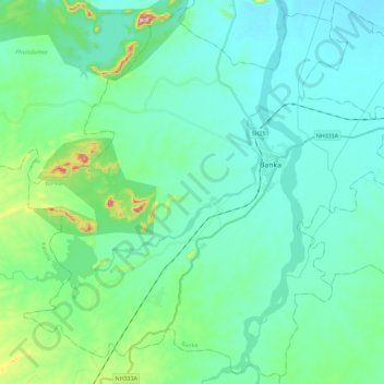
Name: Banka topographic map, elevation, terrain.
Location: Banka, Bihar, 813102, India (24.76542 86.77156 24.96676 87.00193)
Average elevation: 112 m
Minimum elevation: 64 m
Maximum elevation: 338 m
Other topographic maps
Click on a map to view its topography, its elevation and its terrain.
Purnia
India > Bihar > Purnia East
Purnia, Purnia East, Purnia District, Bihar, 854301, India
Average elevation: 38 m
Sheikhpura
India > Bihar > Sheikhpura
Sheikhpura, Sheikhpura District, Bihar, 803109, India
Average elevation: 49 m
Sonbhadra
India > Bihar > Sonbhadra Banshi Suryapur
Sonbhadra, Sonbhadra Banshi Suryapur, Arwal District, Bihar, 824120, India
Average elevation: 74 m
10
India > Bihar > Patna Rural > Patna
10, Patna, Patna Rural, Patna District, Bihar, 800001, India
Average elevation: 54 m
Rajgir Forests
Rajgir Forests, Muhra, Gaya, Bihar, 805112, India
Average elevation: 95 m
Patna
India > Bihar > Patna Rural
Patna, Patna Rural, Patna District, Bihar, 800001, India
Average elevation: 51 m