
Make a donation
Darbhanga topographic map
Click on the map to display elevation.
Make a donation
Darbhanga
Darbhanga is located in the northern part of Bihar. It lies between 25.53 degrees - 26.27 degrees N and 85.45 degrees - 86.25 degrees E at an average elevation of 171 feet (52 m). Darbhanga district covers an area of 2,279 sq km. Darbhanga is bounded by Madhubani district in the north, Samastipur district in the south, Saharsa district in the east, and Sitamarhi district and Muzaffarpur district in the west. Being located in Mithilanchal, Darbhanga district has a vast fertile alluvial plain devoid of any hills. It has a gentle slope from north to south direction having a depression in the centre. Darbhanga experiences a humid subtropical climate. It experiences three main seasons which are winter, summer, and rainy seasons. May is the hottest month when the temperature reaches up to 43 °C. Darbhanga district receives an average of 1142.3 mm rainfall and almost 92% of the annual rainfall is received during monsoon.
Make a donation
About this map
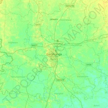
Name: Darbhanga topographic map, elevation, terrain.
Location: Darbhanga, Darbhanga District, Bihar, 846004, India (25.99700 85.73951 26.31700 86.05951)
Average elevation: 50 m
Minimum elevation: 43 m
Maximum elevation: 58 m
Make a donation