Geolocate

Kalamassery topographic map

Interactive map

Click on the map to display elevation.

About this map

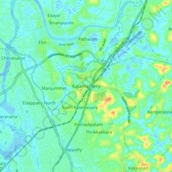
Name: Kalamassery topographic map, elevation, terrain.

Location: Kalamassery, Kanayannur, Ernakulam, Kerala, 683104, India (10.01217 76.27990 10.09217 76.35990)

Average elevation: 10 m

Minimum elevation: -3 m

Maximum elevation: 38 m

Other topographic maps

Click on a map to view its topography, its elevation and its terrain.

Vennala

India > Kerala > Kanayannur > Ernakulam

Average elevation: 8 m

Moovattupuzha

India > Kerala > Kanayannur > Poothotta

Average elevation: 4 m

Chithrapuzha

India > Kerala > Kanayannur > Ernakulam

Average elevation: 9 m

Mulamthuruthy

India > Kerala > Kanayannur > Mulanthuruthy

Average elevation: 21 m

Kochi

India > Kerala > Kanayannur > Ernakulam

Average elevation: 5 m

Edapally

India > Kerala > Kanayannur > Edapally

Average elevation: 9 m