
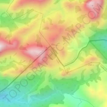
Anamalai topographic map
Interactive map
Click on the map to display elevation.
About this map
Name: Anamalai topographic map, elevation, terrain.
Location: Anamalai, Udumalaipettai, Tiruppur District, Tamil Nadu, India (10.31069 77.09083 10.31388 77.09329)
Average elevation: 2,023 m
Minimum elevation: 1,749 m
Maximum elevation: 2,263 m
Other topographic maps
Click on a map to view its topography, its elevation and its terrain.
Udumalaipettai
India > Tamil Nadu > Udumalaipettai
The town is surrounded by Western Ghats on three sides. The average altitude of the town is 1208 feet above MSL. The topography is undulated and the general slope is from west to North. The town gets major rainfall during the South West monsoon. The average annual rainfall is 501.40 mm. Black and red soil…
Average elevation: 363 m
Udumalaipettai
India > Tamil Nadu > Udumalaipettai
Udumalai is surrounded by Western Ghats on three sides. The average altitude of the town is 1208 feet above MSL. The topography is undulated and the general slope is from west to North. Black clay soil is the predominant soil of the area. The town gets major rainfall during the south west monsoon period. The…
Average elevation: 363 m