
Make a donation
Udumalaipettai topographic map
Click on the map to display elevation.
Make a donation
Udumalaipettai
Udumalai is surrounded by Western Ghats on three sides. The average altitude of the town is 1208 feet above MSL. The topography is undulated and the general slope is from west to North. Black clay soil is the predominant soil of the area. The town gets major rainfall during the south west monsoon period. The average annual rainfall is 501.40 mm. Black and red soil types are found in the town. The soil contains more of alumina and gypsum. While black soil area is utilized for agriculture, the areas with red soil have more urbanized uses.
Make a donation
About this map
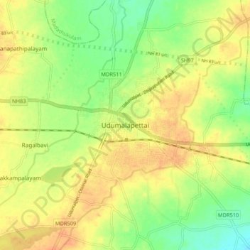
Name: Udumalaipettai topographic map, elevation, terrain.
Location: Udumalaipettai, Tiruppur, Tamil Nadu, 642100, India (10.54390 77.21000 10.62390 77.29000)
Average elevation: 363 m
Minimum elevation: 340 m
Maximum elevation: 381 m
Make a donation
Other topographic maps
Click on a map to view its topography, its elevation and its terrain.
Udumalaippettai
India > Tamil Nadu > Udumalaipettai
The town is surrounded by Western Ghats on three sides. The average altitude of the town is 1208 feet above MSL. The topography is undulated and the general slope is from west to North. The town gets major rainfall during the South West monsoon. The average annual rainfall is 501.40 mm. Black and red soil…
Average elevation: 365 m